
The Ministry of Health will be hosting a virtual Press Conference at 11am this morning (Saturday 25th July 2020) after reporting in its 10am update that there are now five (5) more cases of COVID-19. As of this morning, Trinidad and Tobago has a total of 147 recorded cases.
According to the Ministry, these new cases are not imported as they are the primary contacts of a recently infected patient.
Watch the live stream of the Press Conference below when it begins at 11am.
This is a developing story - refresh this page for updates.
0 Comments
 UPDATE: Chief Medical Officer, Dr. Roshan Parasram, confirmed at a Press Conference that the five (5) latest COVID-19 cases are primary contacts of case # 142. Three (3) children are among those five (5) cases. One child attended the Maraval RC school. Pupils and staff at that school are to go into quarantine. The Ministry of Health revealed in its 10am update this morning (Saturday 25th July 2020) that there are five (5) new positive COVID-19 cases in Trinidad and Tobago. They are not imported. The Ministry notes these new cases are primary contacts of a recently positive COVID-19 patient. The total number of recorded cases now rises to 147. There are currently six (6) patients being treated for COVID-19 at the Caura Hospital and these five (5) new cases are also headed there.   This is a developing story - refresh this page for updates.
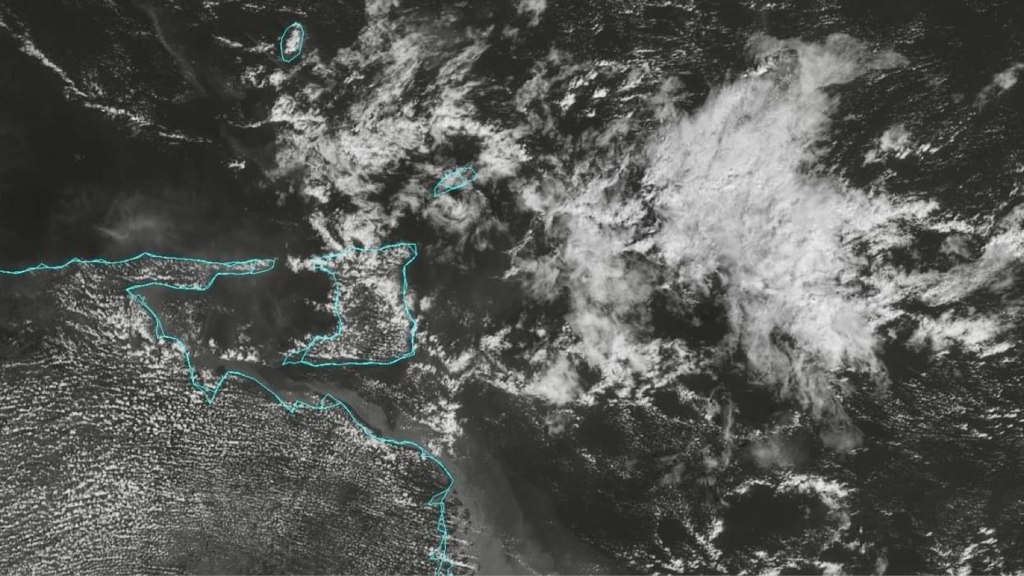 The Office of Disaster Preparedness and Management (ODPM) is urging the public to remain vigilant and continue their preparations as we expect to begin to feel the effects of the passage of Tropical Storm Gonzalo from as early as this morning in some areas of Tobago, North and East Trinidad. This system has so far proven to be a very unpredictable. Notwithstanding this unpredictability, based on the MET Service forecast, it appears that Trinidad and Tobago can expect very heavy rainfall. As such, the ODPM is urging all persons to fully prepare themselves and secure their possessions. The entire Trinidad and Tobago is asked to be ready for this passing weather system. The Trinidad and Tobago Meteorological Service (TTMS) has upgraded its Adverse Weather Alert to Orange Level for Trinidad while a Tropical Storm Warning continues to be in effect for Tobago. Coastal and offshore waters around Tobago and North and East of Trinidad, as well as sheltered areas along Trinidad's coastline are currently under a Hazardous Seas Alert. These conditions are expected to commence today (Saturday 25th July 2020) and persist until Sunday 26th July 2020. Persons should be prepared for heavy rainfall, Thunderstorm activity, strong gusty winds and rough seas conditions. The ODPM is again cautioning persons living in low-lying areas, near river banks, or living/working in flood prone of landslide prone areas, to be extra vigilant and to take the necessary precautions to preserve life and property. Ensure that you have sandbags in place which are accessible from your nearest Municipal Corporation. Look out for vulnerable persons in your community who would need assistance. Additionally, persons in hilly areas should anticipate Landslides and Landslips.  This is a developing story - refresh this page for updates.

UPDATE (2pm): Tropical Storm Gonzalo has been downgraded to a Depression after passing over T&T and the Met Office has discontinued the Adverse Weather Alert for Trinidad and the Tropical Storm Warning for Tobago.
The National Hurricane Center (NHC) in Miami indicated last night that Tropical Storm Gonzalo has moved significantly Southward from its original forecast track. This means Trinidad and Tobago will experience a more direct impact than previously thought, which has prompted the Met Office to upgrade the Adverse Weather Alert for Trinidad as well as the previous Tropical Storm Watch for Tobago.
The NHC noted last night, “The track guidance continues to trend Southward and the NHC track forecast has again been shifted in that direction.”
At 5am this morning (Saturday 25th July 2020), the NHC notes the center of Tropical Storm Gonzalo was located near Latitude 10.1 North, Longitude 58.7 West. Gonzalo is moving toward the West near 18 Mph (30 Km/h). A general westward to west-northwestward motion is expected for the next couple of days. On the forecast track, Gonzalo will move across the Southern Windward islands this afternoon or evening and over the Southeastern Caribbean Sea on Sunday.
Maximum sustained winds are near 40 Mph (65 Km/h) with higher gusts. Little change in strength is expected before Gonzalo reaches the Southern Windward islands later today. Weakening is expected after Gonzalo moves over the Southeastern Caribbean Sea, and the system is forecast to dissipate by Sunday night or Monday. Tropical-Storm-force winds extend outward up to 25 Miles (35 Km) from the center. Gonzalo is expected to produce total rain accumulations of 1 to 3 inches (25 to 76mm), with isolated maximum amounts of 5 inches (127mm) in Barbados, the Windward Islands and Trinidad and Tobago through Sunday night. Gonzalo is also expected to produce total rain accumulations of 1 to 2 inches (25 to 51mm) in Northeastern Venezuela through Monday. 
This is a developing story - refresh this page for updates.
 UPDATE (2pm): Tropical Storm Gonzalo has been downgraded to a Depression after passing over T&T and the Met Office has discontinued the Adverse Weather Alert for Trinidad and the Tropical Storm Warning for Tobago. The Trinidad and Tobago Meteorological Service (TTMS) has announced that the Adverse Weather Alert for Trinidad has now been upgraded from Yellow Level to Orange Level between 11am to 8pm on Saturday 25th July 2020. A Tropical Storm Warning (Orange Level) was also issued for Tobago on Saturday, which was upgraded from a Tropical Storm Watch. The Met Office notes there is a high (70%) chance of heavy showers or Thunderstorms during the period, which may lead to Street/Flash Flooding as well as Landslides/Landslips in areas so prone. Gusty winds in excess of 65 Km/h can also be experienced in the vicinity of heavy downpours. This event is related to instability associated with the passage of Tropical Storm Gonzalo. Citizens are advised to take immediate actions to protect lives, livelihoods, and property. Stock up on food, water and medicine for at least seven (7) days in waterproof containers. Secure loose outdoor objects and trim tree branches near your home. Prepare and pre-position sandbags if your area floods. The National Hurricane Center (NHC) in Miami indicated last night that Tropical Storm Gonzalo has moved significantly Southward from its original forecast track. This means Trinidad and Tobago will experience a more direct impact than previously thought, which has prompted these recent upgrades by the Met Office.  This is a developing story - refresh this page for updates.
 The Trinidad and Tobago Police Service (TTPS) detained eleven (11) Venezuelans on Thursday (23rd July 2020) while another thirty-three (33) were detained the day before, on Wednesday. There has been a growing concern that illegal immigrants are coming into the country and possibly bringing COVID-19 with them. Minister of National Security, Staurt Young, has promised to investigate. During an anti-crime exercise conducted in the Santa Flora district on Thursday, eleven (11) Venezuelans were detained by Officers of the South-Western Division Task Force. During the exercise, and based on information received, the Officers proceeded to Number 4 Road, Palo Seco, where they saw several persons running into a bushy area. A search was conducted of the area, and eleven (11) illegal Venezuelan immigrants and a T&T National were detained and taken to the Siparia Health facility where they were medically examined by a doctor and then taken to the Chaguaramas Heliport for a 14-day period quarantine. On Wednesday, thirty-three (33) Venezuelans were detained by Officers of the South-Western and Tobago Divisions, during anti-crime exercises. In the Erin district, Officers of the South-Western Task Force received information that took them to Ayres Road, Los Iros beach, where they saw several people disembarking a vessel.
A search was conducted in a bushy area and a total of fifteen (15) Venezuelans were detained, and taken to the Siparia Health facility where they were medically examined and later taken to the Chaguaramas Heliport for a 14-day quarantine period. Meanwhile in Tobago, Officers of Crown Point Police Station, the Criminal Investigation Department (CID), and the Immigration Department, proceeded to guest houses at Gaskin Bay Road, Bon Accord and at Alfred Crescent Bon Accord, where another eighteen (18) illegal Venezuelans were detained, and are at the Crown Point Police Station awaiting to be processed by the Immigration department.  The Trinidad and Tobago Meteorological Service (TTMS) has announced that the Tropical Storm Watch for Tobago has now been upgraded to a Tropical Storm Warning (Orange Level) between 8am to 8pm on Saturday 25th July 2020. An Adverse Weather Alert (Yellow Level) was also issued for Trinidad on Saturday. The Met Office notes as at 2pm today (Friday 24th July 2020), the center of weak Tropical Storm Gonzalo was located near 9.9 N 54.8 W and moving Westward at 30 Km/h. Tropical Storm conditions are expected to affect Tobago from Saturday morning. Periods of heavy to intense showers and/or Thunderstorms are likely. Heavy/intense downpours can result in Street/Flash Flooding. Gusty winds in excess of 85 Km/hr can be expected and the risk of Landslides/Landslips is very high in areas so prone. Sea conditions are also likely to become occasionally rough. Citizens are advised to take immediate actions to protect lives, livelihoods, and property. Stock up on food, water and medicine for at least seven (7) days in waterproof containers. Secure loose outdoor objects and trim tree branches near your home. Prepare and pre-position sandbags if your area floods. An update will be provided by the Met Office at 7pm today or earlier if the situation warrants.  This is a developing story - refresh this page for updates.
 The Trinidad and Tobago Meteorological Service (TTMS) has issued an Adverse Weather Alert (Yellow Level) for nine (9) hours on Saturday 25th July 2020, between 11am and 8pm. The Met Office notes there is a high (70%) chance of heavy showers or Thunderstorms during the period, which may lead to Street/Flash Flooding as well as Landslides/Landslips in areas so prone. Gusty winds in excess of 65 Km/h can also be experienced in the vicinity of heavy downpours. This event is related to instability associated with the passage of Tropical Storm Gonzalo.   This is a developing story - refresh this page for updates.
 As Tropical Storm Gonzalo approaches Trinidad and Tobago, it’s important to have the phone number for the Disaster Management Unit (DMU) in your area in case of an emergency. There is some uncertainty in the forecast track and intensity for Tropical Storm Gonzalo, which could see a more direct impact to both Trinidad and Tobago. Below are the hotline numbers for the Disaster Management Unit in fifteen (15) areas across T&T.   In its 11am update this morning (Friday 24th July 2020), the National Hurricane Center (NHC) in Miami notes that there is considerable uncertainty in the intensity forecast, but some strengthening is still possible during the next day or so before Gonzalo reaches the Southern Windward islands. Weakening is expected after Gonzalo moves into the Caribbean Sea, and the cyclone is expected to dissipate by the middle of next week. A Tropical Storm Warning is in effect for:
A Hurricane Watch is in effect for:
A Tropical Storm Watch is in effect for:
As of 11am, the center of Tropical Storm Gonzalo was located near Latitude 10.0 North, Longitude 54.2 West. Gonzalo is moving toward the West near 18 Mph (30 Km/h). A general westward-to west-northwestward motion is expected during the next couple of days. On the forecast track, the center of Gonzalo will approach the Southern Windward islands tonight and then move across the islands on Saturday and over the Eastern Caribbean Sea on Sunday. Maximum sustained winds are near 50 Mph (85 Km/h) with higher gusts. Gonzalo is a small Tropical Cyclone. Tropical-Storm-force winds extend outward up to 25 Miles (35 Km) from the center. Gonzalo is expected to produce total rain accumulations of 2 to 5 inches (51 to 127mm) with isolated maximum amounts of 8 inches (203mm) in Barbados and the Windward islands through Sunday night. Gonzalo is also expected to produce total rain accumulations of 2 to 4 inches (51 to 102mm) in Trinidad and Tobago as well as 1 to 2 inches (25 to 51mm) over Northeastern Venezuela. Rainfall in Barbados and the Windward islands could lead to life-threatening Flash Floods. 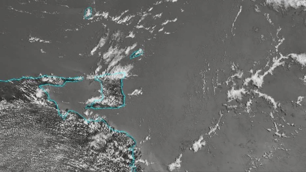 This is a developing story - refresh this page for updates.
|
AboutYouthere1 is a website focused on providing useful information, breaking news, entertainment and online shopping in Trinidad and Tobago.
AlertsSupportYouTubeContactPrivacyCategories
All
Archives
May 2024
|
 RSS Feed
