 UPDATE: In a social media post this afternoon, RBC confirmed it has been affected. In a notice to its clients, the bank said, “RBC, along with many other businesses, is experiencing varying degrees of the global I.T. outage impacting organizations around the world. We are actively investigating and solutions are being deployed. Clients may have difficulty accessing their account information and may experience delays in their transactions. Our teams are working diligently to restore access as soon as possible. Thank you for your patience and we apologize for the inconvenience.” According to reports, local branches of RBC may have also been affected by the global I.T. outage which has impacted several sectors from early this morning (Friday 19th July, 2024).
Guardian Media said it has seen an internal memorandum which was sent to RBC’s Caribbean banking division, stating: “Due to a global outage beyond our control, different business sectors worldwide, including RBC, have been affected. As a result, some of our Caribbean banking applications are currently down, which is impacting our operations, and the ability of our clients to transact via ATM, POS (Point of Sale) and digital banking.” The memo notes that “a fix has been deployed” but it may take some time before all systems are fully operational again. More on this as it becomes available. [Source: CNC3]
0 Comments
 In response to the devastating impact of Hurricane Beryl on the islands of Grenada and Carriacou, the Government of the Republic of Trinidad and Tobago, through the Ministry of Energy and Energy Industries, has co-ordinated with Paria Fuel Trading Company Limited (PARIA) to deliver an emergency supply of fuel to both islands at no cost to the Government of Grenada.
In a Media Release on Saturday (6th July, 2024), the Ministry of Energy and Energy Industries said, “With the assistance of Trinity Liftboat Services and SOL EC Limited, engaged by PARIA for transportation, a total of 380 barrels of High Sulphur Diesel were successfully delivered to Carriacou, and 820 barrels of Ultra-Low Sulphur Diesel (ULSD) were delivered to Grenada on Friday, July 5, 2024.” “The swift and efficient delivery of these fuel supplies is crucial for the recovery and rebuilding efforts in Grenada and Carriacou,” said the Honourable Minister of Energy, Mr. Stuart R. Young, SC, MP. “We are committed to standing by our Caribbean neighbours during this difficult time and providing the necessary support to help them rebuild and recover.” The Media Release concluded by saying, “The Ministry of Energy and Energy Industries and PARIA extends its gratitude to all parties involved in this operation, Trinity Liftboat Services, and SOL EC Limited for their dedicated efforts in ensuring the successful delivery of these critical resources.” 
The Steelpan is now legally Trinidad and Tobago’s national instrument. Senator the Honourable Randall Mitchell, Minister of Tourism, Culture and the Arts, piloted the debate on The National Musical Instrument Bill, 2024 in the House of Representatives on Wednesday (3rd July, 2024).
This Bill provides for the designation of the Steelpan as the National Musical Instrument of the Republic of Trinidad and Tobago. After being read a third time, it was passed in the House of Representatives.
Minister Mitchell said this decision marks a significant milestone for the Steelpan movement and the nation as a whole as it solidifies the Steelpan's cultural importance in Trinidad and Tobago. He said the Steelpan serves as an important thread in this country's cultural tapestry.
[Source: TTT Live Online]
In a demonstration of solidarity, the Government of Trinidad and Tobago is extending critical aid to Caribbean nations impacted by Hurricane Beryl.
Today (Wednesday 3rd July, 2024), Senator the Honourable Rohan Sinanan, Minister of Works and Transport, alongside Senator the Honourable Paula Gopee-Scoon, Minister of Trade and Industry, oversaw the loading of relief supplies including food, beverages and water, personal hygiene products, medical and healthcare items, construction materials, mattresses and generators at the Port of Port-of-Spain. In a Media Release earlier today, the Ministry of Works and Transport (MOWT) said these essential supplies, donated by various members of the business community, “are being loaded onto the Galleons Passage cargo vessel bound for St. Vincent and the Grenadines.”
The Ministry notes that on Tuesday (2nd July, 2024), Trinidad and Tobago dispatched a shipment of vital supplies to Grenada.
Upon the Galleons Passage's return from St. Vincent and the Grenadines, the Ministey said another shipment “will promptly depart for Grenada to further augment relief efforts.” The Media Release concluded by saying, “The Government of Trinidad and Tobago remains steadfast in its commitment to supporting its Caribbean counterparts during this challenging period. We stand ready to assist in meeting critical needs as our neighbours continue their recovery efforts from the impact of Hurricane Beryl.” 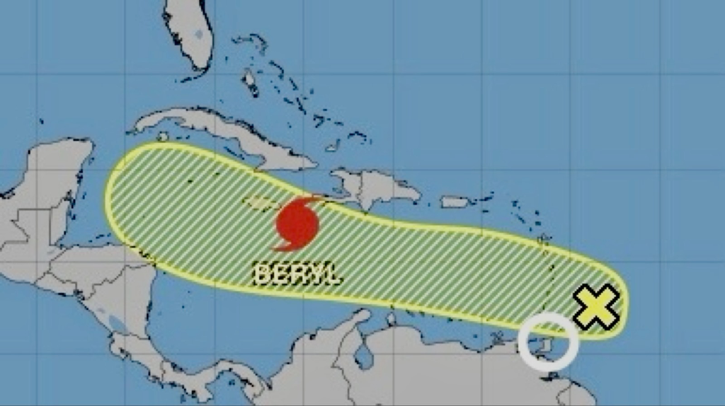 The Trinidad and Tobago Meteorological Service (TTMS) said it continues to monitor an active Tropical Wave (AL96) in the Tropical Atlantic, just East of the Windward Islands. At 8:00 AM today (Wednesday 3rd July, 2024), the axis of the Tropical Wave was located near 58W longitude (near 157 km) East of the Windward Islands, moving Westward at 30 - 40 km/h.
Heavy rainfall, thunderstorms and gusty winds have already begun affecting parts of the Windward Islands. Despite this activity, current environmental conditions appear only marginally conducive for further development. At 8:00 AM, the National Hurricane Center (NHC) in Miami has given the system a low (10%) chance of developing into a Tropical Depression over the next forty-eight (48) hours and a low (20%) over the next seven (7) days. The Met Office notes that most activity associated with AL96 is forecast to remain North of Trinidad and Tobago. However, there is a medium (40%) chance of isolated heavy showers/thunderstorms which may be accompanied by gusty winds. The TTMS said it will continue to monitor AL96 as it moves through the region. The last official statement for AL96 will be issued at 3:00 PM today (Wednesday 3rd July, 2024), or early if the situation warrants. Please continue to pay attention to the latest forecasts, alerts, and information issued by the TTMS. More on this as it becomes available. This is a developing story - refresh this page for updates. P.M. Rowley On Beryl: Relief Supplies On Way To Grenada, St. Vincent; Children Allowed Into T&T2/7/2024  CARICOM Heads met in a virtual session today (Tuesday 2nd July, 2024) and received updated reports of the devastation of the Grenadines territories of Grenada and St. Vincent and the Grenadines, due to the passage of Hurricane Beryl. This according to Prime Minister Keith Rowley in a Facebook post this morning.
The Prime Minister added, “It was reported by Prime Minister Mitchell of Grenada that Carriacou has been totally wrecked by Hurricane Beryl. Similarly, Prime Minister Gonzalves of St. Vincent and the Grenadines reported on the devastation of Canouan, Union Island and Mayreau. The Government of Trinidad and Tobago is mobilizing relief supplies to be urgently despatched by marine crafts tonight.” The statement concluded by saying, “Given the level of total devastation experienced on these islands, the Government of Trinidad and Tobago, acknowledging the deep familial ties between these islands and Trinidad and Tobago, has offered to allow school-age children from the devastated zones to be allowed into Trinidad and Tobago if they have family here, who may wish to house them during the school holiday period, which is upon us at this time.” In a Facebook post on Monday (1st July, 2024), following the passage of Hurricane Beryl, Prime Minister Rowley said, “Trinidad and Tobago survived Beryl without too much bruising. I extend my sincerest thanks to all my Colleagues in CARICOM who reached out to commit assistance to the people of T&T even as the Hurricane was bearing down upon us. We stand ready to offer support to Grenada and St. Vincent and the Grenadines at this time as we pray ‘there but for the grace of God go I.’” More on this as it becomes available. 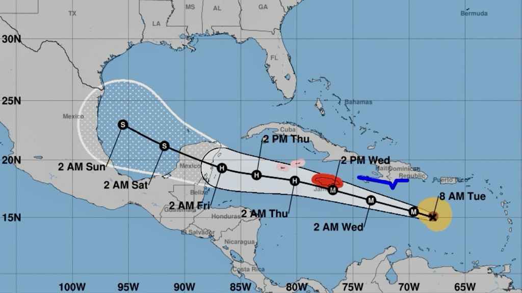
The National Hurricane Center (NHC) in Miami said in its 8:00 AM Public Advisory this morning (Tuesday 2nd July, 2024) that Beryl, now a Category 5 Hurricane, is expected to bring life-threatening winds and storm surge to Jamaica on Wednesday. Hurricane Hunter aircraft report little change in strength over the past few hours.
Beryl now becomes the earliest Category 5 on record in the Atlantic basin. SUMMARY OF WATCHES AND WARNINGS IN EFFECT: A Hurricane Warning is in effect for:
A Hurricane Watch is in effect for:
A Tropical Storm Warning is in effect for:
DISCUSSION AND OUTLOOK
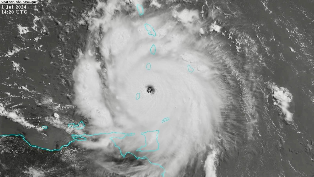
At 8:00 AM AST (12:00 UTC), the eye of Hurricane Beryl was located near latitude 15.0 North, longitude 67.9 West. Beryl is moving toward the West-Northwest near 22 mph (35 km/h) and is forecast to continue moving rapidly West-Northwestward during the next couple of days and turn Westward by Thursday (4th July, 2024). On the forecast track, the center of Beryl will move quickly across the Southeastern and Central Caribbean Sea today (Tuesday 2nd July, 2024) and is forecast to pass near Jamaica on Wednesday and the Cayman Islands on Thursday. Reports from NOAA and Air Force Reserve Hurricane Hunter aircraft indicate that maximum sustained winds remain near 165 mph (270 km/h) with higher gusts. Beryl is a category 5 Hurricane on the Saffir-Simpson Hurricane Wind Scale. Weakening should begin later today, but Beryl is still expected to be near major Hurricane intensity as it moves into the Central Caribbean and passes near Jamaica on Wednesday and the Cayman Islands on Thursday. Additional weakening is expected thereafter, though Beryl is forecast to remain a Hurricane in the Northwestern Caribbean. Hurricane-force winds extend outward up to 40 miles (65 km) from the center and Tropical-Storm-force winds extend outward up to 125 miles (205 km). NOAA buoy 42059 to the North of the eye recently reported sustained winds of 72 mph (115 km/h) and a wind gust of 94 mph (151 km/h). The minimum central pressure estimated from the Hurricane Hunter aircraft data is 934 mb (27.58 inches). More on this as it becomes available. This is a developing story - refresh this page for updates. 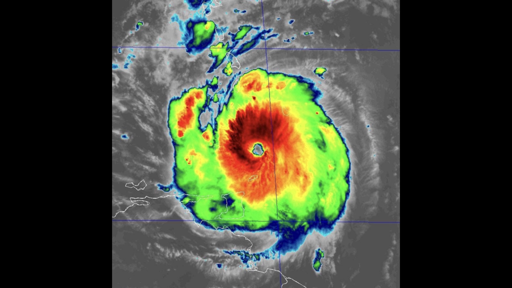
According the the National Hurricane Center (NHC) in Miami, Hurricane Hunter aircraft data indicates that Beryl has once again strengthened to an extremely dangerous category 4 Hurricane, with life-threatening winds and storm surge expected to begin in the Windward Islands this morning (Monday 1st July, 2024).
WATCHES AND WARNINGS CHANGES WITH THIS ADVISORY:
SUMMARY OF WATCHES AND WARNINGS IN EFFECT: A Hurricane Warning is in effect for:
A Tropical Storm Warning is in effect for:
A Tropical Storm Watch is in effect for:
DISCUSSION AND OUTLOOK
At 8:00 AM AST (12:00 UTC), the eye of Hurricane Beryl was located near latitude 12.0 North, longitude 60.5 West. Beryl is moving toward the West-Northwest near 20 mph (31 km/h). A continued quick Westward to West-Northwestward motion is expected during the next few days. On the forecast track, the center of Beryl is expected to move across the Windward Islands this morning and across the Southeastern and Central Caribbean Sea late today through Wednesday. Data from the NOAA and Air Force Hurricane Hunters indicate that maximum sustained winds have increased to near 130 mph (215 km/h) with higher gusts. Beryl is a category 4 Hurricane on the Saffir-Simpson Hurricane Wind Scale. Fluctuations in strength are likely during the next day or so, but Beryl is expected to remain an extremely dangerous major Hurricane as its core moves through the Windward Islands into the Eastern Caribbean. Some weakening is expected in the Central Caribbean by midweek, though Beryl is forecast to remain a Hurricane. Hurricane-force winds extend outward up to 35 miles (55 km) from the center and Tropical-Storm-force winds extend outward up to 125 miles (205 km). Grantley Adams International Airport in Barbados recently reported sustained winds of 47 mph (76 km/h) with a gust to 69 mph (111 km/h). The estimated minimum central pressure based on dropsonde data is 959 mb (28.32 inches). More on this as it becomes available. This is a developing story - refresh this page for updates. 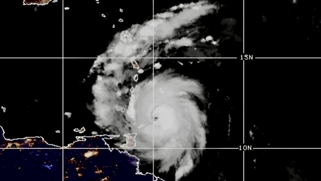
According to the Trinidad and Tobago Meteorological Service (TTMS) at 5:10 AM this morning (Monday 1st July, 2024), Trinidad is presently under a Tropical Storm Warning (Orange Level), which remains in effect until 12:00 PM today. This means there is a high potential for Tropical Storm conditions, including sustained winds of 63 - 118 km/h, within the warning area over the next seven (7) hours.
As of 5:00 AM, Hurricane Beryl was located near 11.9°N 59.9°W, approximately 93 km Northeast of Tobago, moving Westward near 31 km/h. There is currently a high (80%) chance of hazardous seas with large, battering waves. Mariners should expect wave heights to increase significantly, posing a danger to small craft, coastal and offshore activities. Strong currents and choppy seas will make navigation hazardous. Showers and/or thunderstorms can be accompanied by wind gusts exceeding 55 km/h associated with Beryl’s outer bands.
Instructions:
The Met Office said the next update will be issued at 8:00 AM this morning (Monday 1st July, 2024), or earlier if necessary. Please continue to pay attention to the latest forecasts, alerts, and information issued by the TTMS. More on this as it becomes available. This is a developing story - refresh this page for updates.  With the threat of Hurricane Beryl bearing down on Trinidad and Tobago in the coming hours, Digicel said it has put its Hurricane Contingency Plan into high gear to ensure that everything is in place to best manage the events of the coming days.
In a Media Release earlier today (Sunday 30th June, 2024), Digicel said, “Specifically, all Digicel retail stores in Tobago will be closed on Monday, July 1, 2024. Additionally, Digicel has zero-rated TEMA's emergency numbers, 866-4211 and 226-8485, allowing customers to call for help without needing an active plan or credit on their accounts.” Digicel said it has ensured that all cell sites across the island are in optimal condition and ready for operation. The company has power generator contractors on standby in both Trinidad and Tobago, and civil engineering crews have been activated on the ground in Tobago. Abraham Smith, CEO of Digicel Trinidad and Tobago, emphasized the importance of safety and preparedness: “Our primary concern is the safety of the people of Trinidad and Tobago. We urge everyone to take the necessary steps to secure their homes and ensure their phones are charged and topped-up for communication with loved ones. We have mobilized our technical teams and field engineers across the island to ensure swift recovery efforts following the passage of Hurricane Beryl.” |
AboutYouthere1 is a website focused on providing useful information, breaking news, entertainment and online shopping in Trinidad and Tobago.
AlertsSupportYouTubeContactPrivacyCategories
All
Archives
July 2024
|
 RSS Feed
