
UPDATE (2:30pm): A heavy Thunderstorm is occurring right now in Chaguanas. Street/Flash Flooding is expected.
UPDATE (2pm): Periphery effects from Feeder Bands (Bands of showers and possible Thunderstorms) are possible across Trinidad & Tobago, particularly later this afternoon through Tuesday. This may bring locally heavy rainfall, gusty winds to parts of T&T over the next 24-48 hours. These showers will remain mostly isolated to scattered. No widespread rainfall or severe weather is expected (via @TTWeatherCenter).
UPDATE (11am): A Hurricane Watch has been issued for St. Lucia. The risks of direct impacts from wind and rainfall has increased for Puerto Rico and Hispaniola.
UPDATE (9:50am): A Nationwide shutdown will begin across Barbados at 10am today - which is 2 hours earlier than expected.
According to the National Hurricane Center (NHC), Tropical Storm Dorian is now compact and getting better organized. It is expected to bring Tropical Storm conditions to the Windward Islands later today (Monday 26th August 2019).
A Hurricane Watch is currently in effect for:
A Tropical Storm Warning is currently in effect for:
A Tropical Storm Watch is currently in effect for:
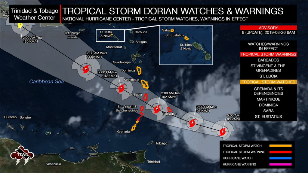
A Hurricane Watch means that Hurricane conditions are possible within the watch area, in this case, within the next 24 hours.
A Tropical Storm Warning means that Tropical Storm conditions are expected somewhere within the warning area within 36 hours. A Tropical Storm Watch means that Tropical Storm conditions are possible within the watch area, generally within 48 hours. Trinidad & Tobago is not forecast to experience direct impacts from Tropical Storm Dorian, although periphery effects are likely, beginning during the latter half of Monday. Interests in Puerto Rico, the Virgin Islands, and Hispaniola should monitor the progress of Dorian as Watches could be required as early as later today. 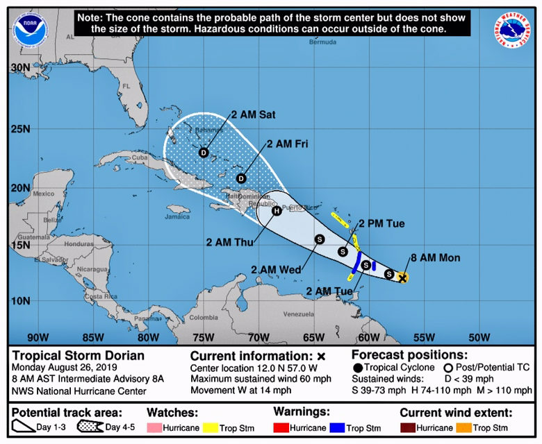
As of 11am this morning, the center of Tropical Storm Dorian was located near Latitude 12.3 North and Longitude 57.7 West, which is about 135 Miles (220 Km) ESE of Barbados. Dorian is moving toward the West-Northwest near 14 Mph (22 Km/h) and this motion is expected to continue through Tuesday night, followed by a turn toward the Northwest on Wednesday. On the Forecast Track, the center of Dorian is expected to be near the Windward Islands late today and tonight, and move into the Eastern Caribbean Sea on Tuesday. Dorian is expected to pass near or South of Puerto Rico on Wednesday and approach Eastern Hispaniola Wednesday night.
Maximum sustained winds are near 60 Mph (95 Km/h) with higher gusts. Some strengthening is forecast during the next few days, and Dorian could be near Hurricane strength when it passes through the Northern Windward Islands on Tuesday, and is expected to be a Hurricane when it moves near Puerto Rico and Eastern Hispaniola. Dorian is a small Tropical Cyclone. Tropical-Storm-force winds only extend outward up to 45 Miles (75 Km) from the center. 
Dorian is expected to produce total rain accumulations of 3 to 8 inches in the Windward Islands from Martinique, South to St. Vincent, including Barbados. Isolated maximum totals of 10 inches are possible across the Northern Windward Islands. Rainfall totals of 1 to 3 inches are expected from the Grenadines, South to Grenada and across Dominica.
Hurricane conditions are possible tonight and early Tuesday within the Hurricane Watch area in the Lesser Antilles. Tropical Storm conditions are likely in the warning area by late today. Tropical Storm conditions are possible within the Tropical Storm Watch area by tonight or Tuesday. Swells generated by Dorian will be affecting portions of the Lesser Antilles by late today. These swells could cause life-threatening surf and rip current conditions. This is a developing story - stay tuned for updates.
0 Comments
Leave a Reply. |
AboutYouthere1 is a website focused on providing useful information, breaking news, entertainment and online shopping in Trinidad and Tobago.
AlertsSupportYouTubeContactPrivacyCategories
All
Archives
March 2024
|
 RSS Feed
