
UPDATE (22/09/19 - 8am): T&T is now under a Tropical Storm Warning as the Tropical Wave was upgraded to Tropical Storm Karen. The Met Office has also issued a Red Level Alert for this Tropical Storm.
UPDATE (21/09/19): The Met Office has now raised its Adverse Weather Alert to Orange Level ahead of this intense Tropical Wave.
Ahead of a strong Tropical Wave, the Trinidad and Tobago Meteorological Service has issued an Adverse Weather Alert (Yellow Level) from 6am on Sunday 22nd September to 8pm on Monday 23rd September 2019.
The Alert Level has been raised to yellow, as the approaching Tropical Wave is likely to affect T&T between Sunday 22nd September and Monday 23rd September 2019. There is medium (40-60%) chance of heavy to intense showers and/or Thunderstorms developing from Sunday morning. Significant rainfall will continue into Monday. Heavy/intense downpours will lead to Street/Flash Flooding. Gusty winds in excess of 65 Km/hr can be expected. The risk of Landslides/Landslips is very high in areas so prone.
See the Adverse Weather Alert from the Met Office below and stay tuned for updates as the weekend progresses. 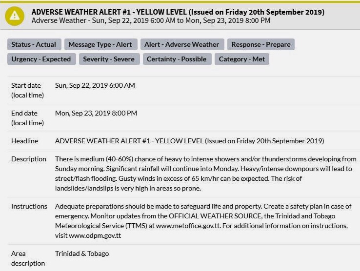
0 Comments
Leave a Reply. |
AboutYouthere1 is a website focused on providing useful information, breaking news, entertainment and online shopping in Trinidad and Tobago.
AlertsSupportYouTubeContactPrivacyCategories
All
Archives
March 2024
|
 RSS Feed
