UPDATE (24/09/19 - 6pm): The Adverse Weather Alert was discontinued before 4pm on Monday 23rd September 2019 and the Riverine Flood Warning was discontinued around 1:30pm on Tuesday 24th September 2019. Thank you for following and sharing our weather updates over these past few days!
UPDATE (22/09/19 - 6:30pm): The Trinidad and Tobago Police Service (TTPS) has blocked motorists from attempting to drive through flood waters on the Highways by Grand Bazaar.
UPDATE (22/09/19 - 4:30pm): Minister of National Security, Stuart Young, has announced that all Schools across Trinidad & Tobago will be closed on Monday 23rd September 2019.
UPDATE (22/09/19 - 3pm): The Met Office has discontinued the Tropical Storm Warning as Karen is moving away, but T&T is now under an Adverse Weather Alert (Orange Level) as well as a Riverine Flood Warning (Red Level).
UPDATE (22/09/19 - 8am): T&T is now under a Tropical Storm Warning as the Tropical Wave was upgraded to Tropical Storm Karen. The Met Office has also issued a Red Level Alert for this Tropical Storm.
UPDATE (21/09/19 - 8pm): While this strong Tropical Wave does not yet have a well-defined circulation, a NOAA Hurricane Hunter mission earlier this afternoon indicated that the Wave is producing winds of 35 Mph (56 Km/h). At least gradual development of this system is expected, and a Tropical Depression or Tropical Storm could form during the next couple of days. Regardless of development, heavy rainfall is still forecast across T&T.
UPDATE (21/09/19 - 2pm): The Met Office has now raised its Adverse Weather Alert to Orange Level ahead of this intense Tropical Wave.
UPDATE: Due to the intensity of this approaching Tropical Wave, the Met Office has issued an Adverse Weather Alert for 38 hours. Be prepared and stay tuned for further updates.
The Trinidad and Tobago Meteorological Service as well as the National Hurricane Center (NHC) are both monitoring a Tropical Wave that is expected to bring significant rainfall to T&T between Sunday 22nd September and Monday 23rd September 2019.
According to the Met Office, the chance of Tropical Cyclone development remains low, however, persons should be prepared in the event that changes occur. Regardless of development, heavy rainfall is forecast across T&T and the Southern Windward Islands on Sunday and into Monday. Seas are forecast to become moderate to rough from late Saturday through Monday. There will also be an elevated threat of Street/Flash/Riverine Flooding on Monday, as well as Landslides and gusty winds. If you live in flood-prone areas or areas susceptible to Landslides, make sure you have an emergency plan in place and supplies available in case of an emergency. 
T&T is not currently under an Alert or Tropical Storm Watch/Warning at this time, but there is a possibility that this may change soon.
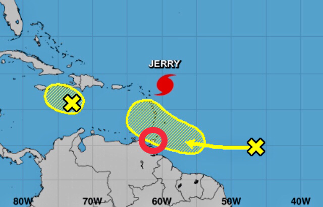
As of 8am this morning (Friday 20th September 2019), the Tropical Wave was located about 700 Miles (1,127 Kilometers) East of the Windward Islands and continues to produce disorganized showers and Thunderstorms. The Wave is expected to move quickly Westward at about 20 Mph (32 Km/h) during the next few days, and some development is possible while it approaches and moves across the Windward Islands this weekend. 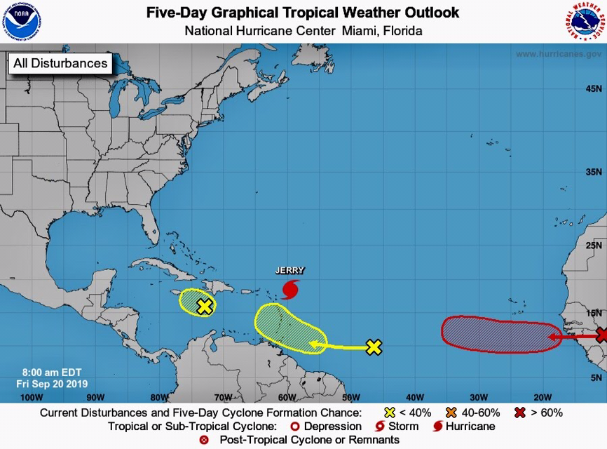
This is a developing story - stay tuned for updates.
0 Comments
Leave a Reply. |
AboutYouthere1 is a website focused on providing useful information, breaking news, entertainment and online shopping in Trinidad and Tobago.
AlertsSupportYouTubeContactPrivacyCategories
All
Archives
March 2024
|
 RSS Feed
