Met Office Monitoring Tropical Wave - Forecast To Affect T&T On Wednesday 16th October 201914/10/2019 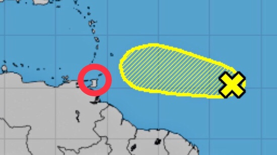 UPDATE (4pm): The Met Office continues to closely monitor this Tropical Wave, located East of T&T. The axis is expected to pass over T&T Wednesday night into Thursday, slightly increasing the potential for Thunderstorms on both days. This Wave is expected to continue on a West-Northwesterly track and most of the activity is expected to occur North of T&T, but this can change. UPDATE (2pm): The National Hurricane Center (NHC) has increased the formation chance for development of this system to 20% through the next 48 hours and 20% through the next 5 days. Thunderstorm activity has continued to increase and the system has become a little better organized. Both the Trinidad and Tobago Meteorological Service and the National Hurricane Center (NHC) are monitoring a Tropical Wave that is forecast to begin affecting T&T from Wednesday 16th October 2019. Locally heavy rainfall and Thunderstorms are possible and there is the threat of Street/Flash Flooding on Wednesday and into Thursday. Gusty winds in excess of 65 Km/h are also possible. Winds of this strength can produce wind damage, including downed trees, utility poles and roof damage. Localized power outages are possible. This Tropical Wave is currently located over the Central Tropical Atlantic and is producing disorganized cloudiness and Thunderstorms. While Thunderstorm activity has increased since yesterday (Sunday 13th October 2019), upper-level winds are not particularly conducive for significant development of this system over the next couple of days while it moves Westward at around 24 Km/h. By Wednesday, as the Wave approaches the Windward Islands, upper-level winds are forecast to become quite hostile for any further development. Formation chance through the next 48 hours is low (10%). Formation chance through the next 5 days is also low (10%). 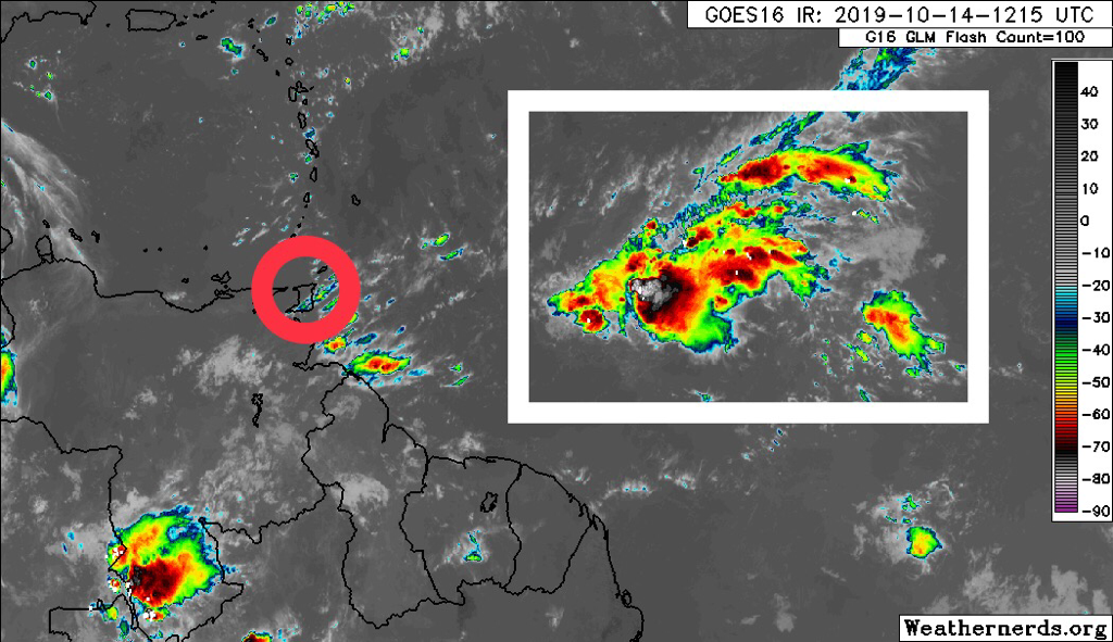 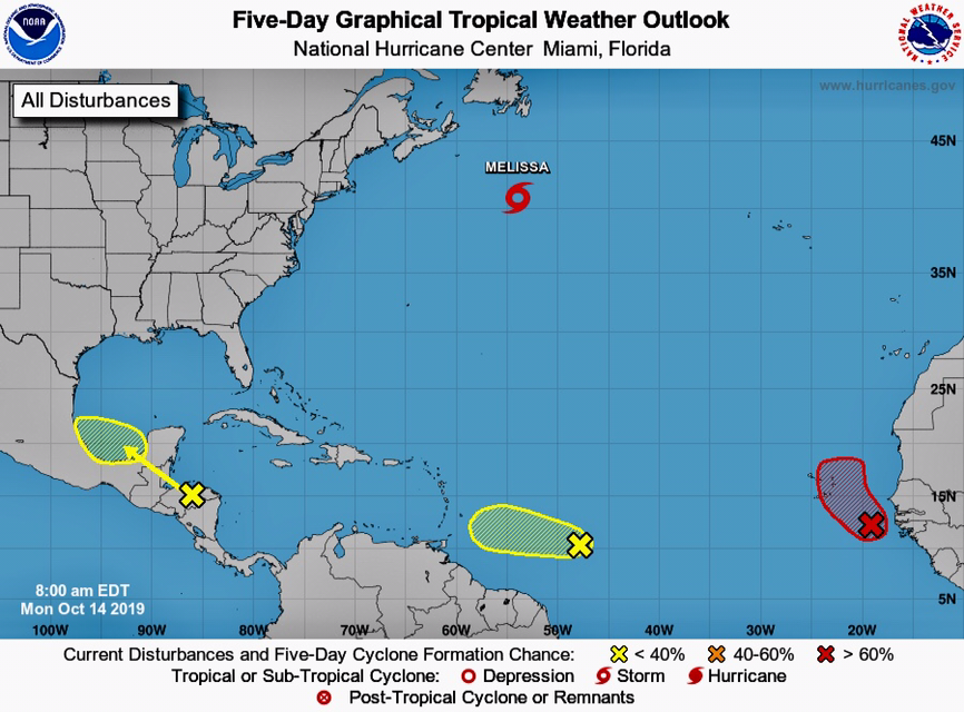 This is a developing story - stay tuned for updates.
0 Comments

UPDATE: Quick work by Officers of the Special Operations Response Team (SORT) resulted in the arrest of two (2) of the bandits in a white AD Wagon in La Horquetta. See the Media Release below from TTPS for additional details.
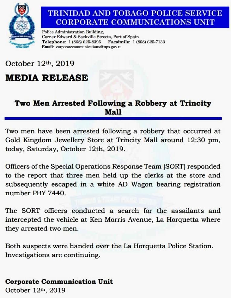
Shoppers were sent scampering in Trincity Mall this afternoon (Saturday 12th October 2019) when three (3) armed men attempted to rob Gold Kingdom Jewelry Store on the Ground Floor. Details are still sketchy but initial reports indicate the men fired several shots before running away. It is unclear at this time if they left with any jewelry or cash.
See a statement from the Management of Trincity Mall below and stay tuned for updates.
Be advised that Trincity Mall remains open for business as usual. As you go about your business in the Mall be aware of your surroundings and do not hesitate to contact mall security, should you feel unsafe. Security officers are out and about in all areas of the mall to ensure that you have a safe and enjoyable shopping experience. 
The Trinidad and Tobago Police Service (TTPS) will be launching their Mobile App on 1st November 2019, which will provide citizens with useful real-time alerts along with numerous other services.
The App will be available on both iOS and Android when it launches. Watch the promo video from TTPS below and let us know your thoughts in the comments.
UPDATE: Fallen Light Poles have been reported by the St. Ann’s Roundabout around 4:30pm. Drivers should exercise caution in that area and expect traffic delays.
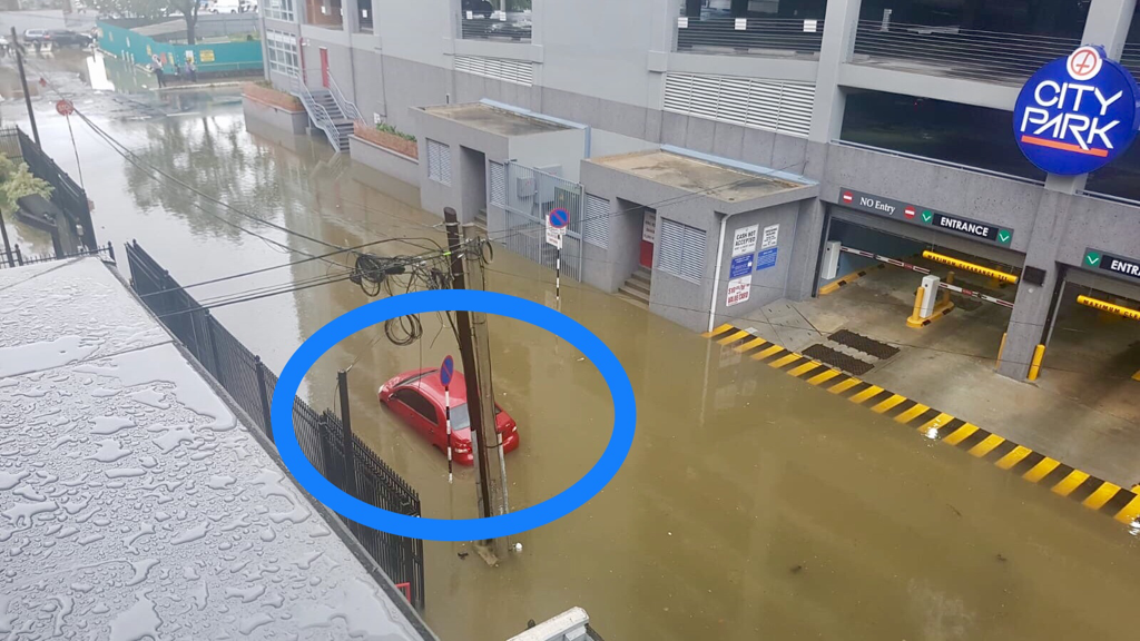
Heavy showers and Thunderstorms moved across Port-of-Spain and environs this afternoon (Thursday 10th October 2019) during High Tide, which is causing flooding across the Capital as of 3:30pm. Delay travel if possible.
Flooding has also been reported at City Gate as of 3:30pm.
As of 3:40pm, the Maraval River is overtopping its banks in a few locations. The San Juan River continues to overtop its banks. The Caroni River remains within its banks. The Aranguez River is high, but within its banks. Stay tuned for updates and remember we are under an Adverse Weather Alert (Yellow Level) until 6pm tonight, Thursday 10th October 2019.
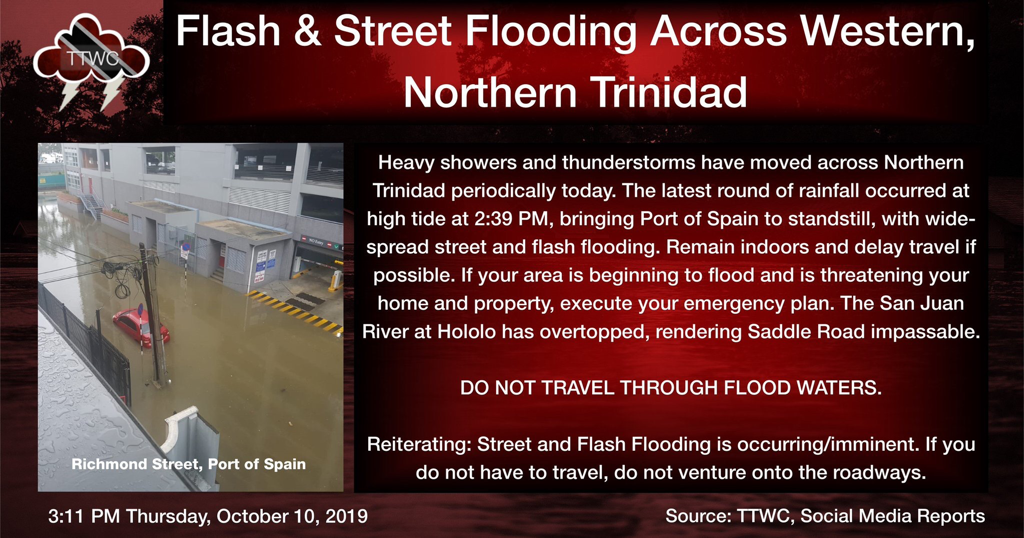
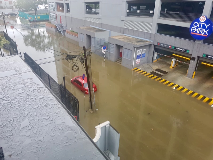
[Source: @TTWeatherCenter]

UPDATE 2: Minister of National Security, Stuart Young, stated at a Press Conference that the Church was not currently an approved facility to house persons under the Mental Health Act. The majority of rescued persons were taken to St. Ann’s for assessment, two (2) persons were returned to their families and one was treated at Mt. Hope Hospital.
UPDATE: The “Transformed Life Ministry” Church in Arouca received approximately $7.4 Million from the State between 2010 and 2015. The last cheque payment was dated 6th August 2015. The State gave the Church money as part of a Subvention (funds provided to assist in the operation of a particular social development programme).
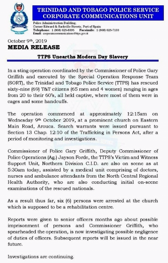
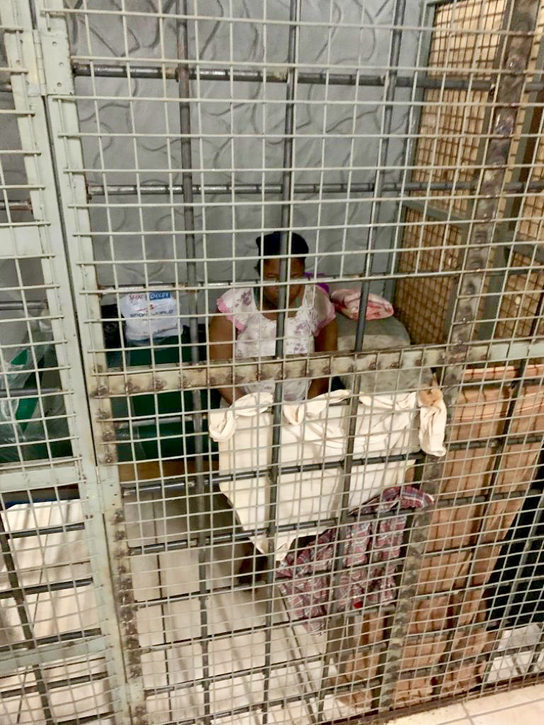
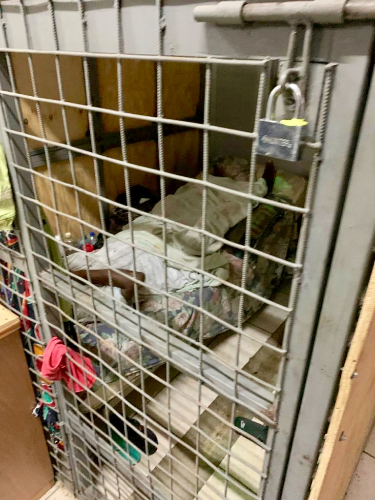
Members of the Special Operation Response Team (SORT), led by Commissioner of Police, Gary Griffith, went to a Church in Arouca at around 11pm on Tuesday 8th October 2019 and discovered 69 people (65 men, 4 women) being held against their will. Their ages range from 20’s to 60’s and all are T&T citizens. Among the group were some mentally-challenged persons. Some of the detainees claim they have been there for years.
Tasers and Batons were also found on the compound of the “Transformed Life Ministry” Church in Arouca, indicating that many of the rescued persons may have also been subjected to torture. In addition to being caged, tortured and beaten, it is alleged that the persons were also underfed. A Pastor was among six (6) people arrested and detained for questioning. Commissioner Griffith described the scene as “barbaric” and “virtual modern day slavery.” 
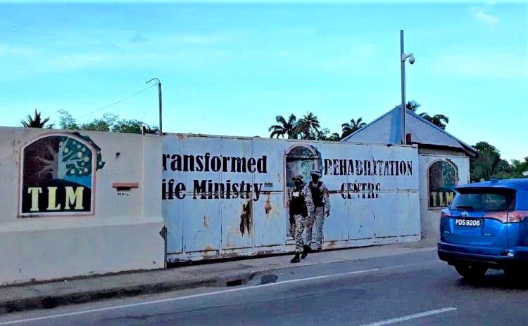
Reports indicate that families would take their drug-addicted relatives to the facility for help with their addictions. At the end of the treatment period, Managers would often advise that the addicts be kept for an additional period, at an additional cost. Family members may not of been aware that their loved ones were being caged and ill-treated as cell phones were not allowed on the compound. A Security Guard was allegedly fired for speaking out about the conditions of the detained persons.
Commissioner Griffith said that all rescued persons would undergo thorough medical examinations. Investigations are continuing. Watch Commissioner Griffith in the pair of videos below as he speaks to CNC3 about the discovery and crime scene.

This is a developing story - stay tuned for updates.

UPDATE (10/10/19 - 1pm): Intense showers and Thunderstorms are ongoing over parts of the country, especially over the northern half of Trinidad. This activity is likely to continue into mid/late-afternoon, and conditions should become generally settled afterward (via @TTMetService).
UPDATE (10/10/19 - 12:45pm): It’s now day 3 of this ITCZ-driven rainfall event. Flooding is ongoing across the East-West Corridor, Port-of-Spain and parts of West-Central Trinidad. Floodwaters have entered Trincity Mall (via @TTWeatherCenter).
UPDATE (09/10/19 - 12pm): Heavy showers and Thunderstorms are ongoing across Trinidad, with locally heavy rainfall, gusty winds, thunder and lightning reported. Activity is expected to continue through the afternoon (via @TTWeatherCenter).

Pictured Above: Caroni, facing South along the Uriah Butler Highway.
The Trinidad and Tobago Meteorological Service has issued an Adverse Weather Alert (Yellow Level) from 6am on Wednesday 9th October to 6pm on Thursday 10th October 2019 due to the presence of the Inter-Tropical Convergence Zone (ITCZ).
According to the Met Office, the ITCZ will affect T&T with periods of showers and/or rain and isolated Thunderstorms. The main impacts will include saturated soils, possibility of Landslips and/or Landslides in addition to gusty winds, electrical discharges, Street and/or Flash Flooding. See the Adverse Weather Alert from the Met Office below and stay tuned for updates. 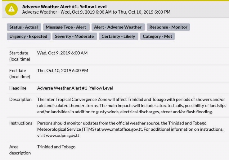
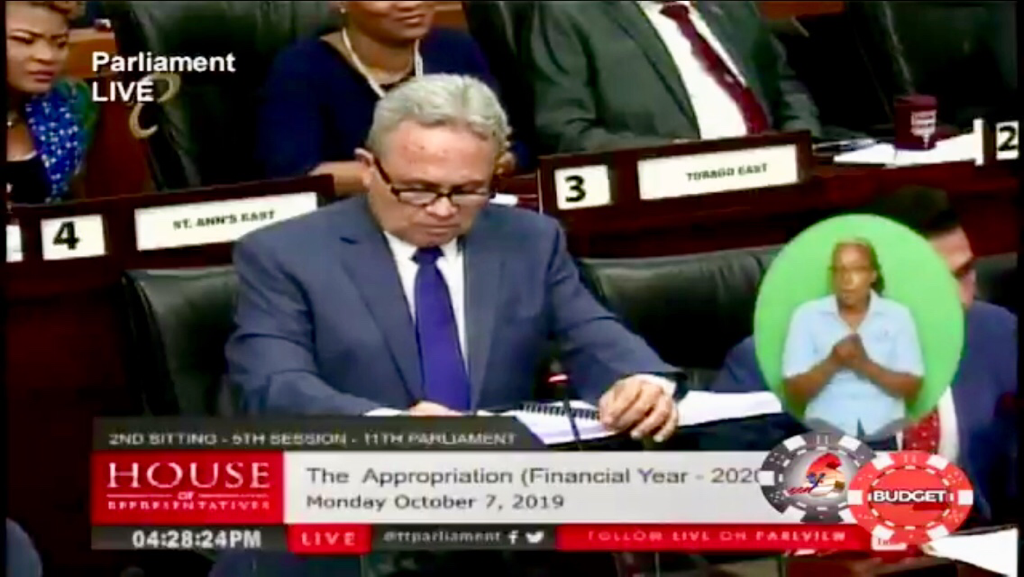
At his Budget 2020 Presentation on Monday 7th October 2019, the Minister of Finance, Colm Imbert, stated that the minimum wage for T&T will soon be increased from $15 to $17.50/Hour. This increase will go into effect from 1st December 2019 and is expected to benefit approximately 194,000 citizens in the workforce.
Watch the Minister’s announcement below and stay tuned for Budget 2020 updates.

Ahead of the passage of a Tropical Wave, the Trinidad and Tobago Meteorological Service has issued an Adverse Weather Alert (Yellow Level) from 2am to 2pm on Thursday 3rd October 2019.
The Tropical Wave is expected to produce periods of showers or rain with the 60 - 80% chance of heavier showers or Thunderstorm activity. Due to prior rainfall events, some ground surfaces are still saturated at this time and will result in the heightened risk of Street/Flash Flooding. Gusty winds in excess of 55 Km/h may accompany heavy downpours and Landslides/Landslips are possible in areas so prone. Although the validity time for this Adverse Weather Alert begins at 2am on Thursday 3rd October 2019, showers can begin to encroach on Southeast Trinidad before this timeframe. It should be noted the likelihood of impacts would be the greatest during the validity time. See the Adverse Weather Alert from the Met Office below and stay tuned for updates. 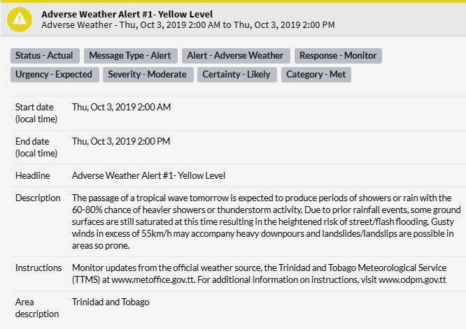

Her Excellency, President Paula-Mae Weekes, in accordance with the provisions of the Public Holidays and Festivals Act, has appointed Sunday 27th October 2019 as the date of the public holiday in celebration of the festival of Divali.
Now, does this mean the day after, Monday 28th October 2019, is also a public holiday? According to the Public Holidays and Festivals Act, Chapter 19:05, 3. (2), yes: Where a public holiday falls on a Sunday or where two public holidays fall on the same day, the next following day that (apart from this subsection) is not a public holiday shall be a public holiday. 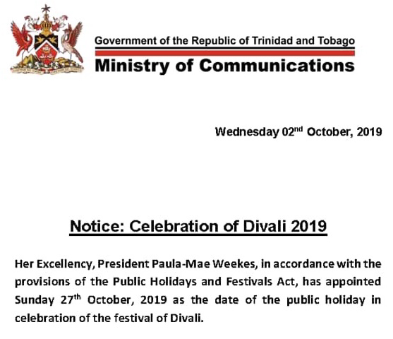
So although not specifically stated in the President’s declaration, we can expect public holidays on both Sunday 27th October and Monday 28th October 2019.
|
AboutYouthere1 is a website focused on providing useful information, breaking news, entertainment and online shopping in Trinidad and Tobago.
AlertsSupportYouTubeContactPrivacyCategories
All
Archives
March 2024
|
 RSS Feed
