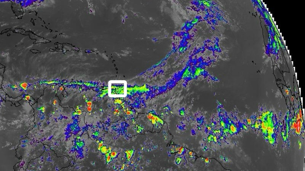
 According to the Trinidad and Tobago Meteorological Service (TTMS), a couple of perturbations across the Leeward Islands is expected to bring mostly mixed conditions for this outlook period (Saturday 11th to Wednesday 15th May, 2024). There will be mostly light to moderate showers at times, interrupting fair conditions in varying areas. The risk for a heavy shower is greatest early on Saturday morning (11th May, 2024), with a 30% chance for a thunderstorm to develop, favouring the most Northerly islands. There is likely to be an increase in moisture advection between Monday (13th May, 2024) and Wednesday (15th May, 2024), when there is expected to be an increase in the mild to moderate showers and a 20% to 30% chance for an isolated heavy shower to develop.
The Windward Islands are expected to see mostly fair conditions, but with patches of moisture advection, bringing a few light or moderate showers in some areas. A strong upper-level wind flow, generally from the West to Southwest, is likely to bring some high-level layered type clouds across Trinidad and Tobago over the next few days. This cloud cover together with the Saharan dust, would give the appearance of dull conditions at times. Otherwise, for most of this outlook period, Trinidad and Tobago is likely to experience fair conditions with a few light or moderate showers in some areas. Saturday (11th May, 2024) will be mostly fair with a brief shower in some areas. On Sunday (12th May, 2024), moisture advection interacting with the land topography can produce a light to moderate shower in some areas, favouring Tobago and Northeast Trinidad during the morning to early afternoon. On Monday (13th May, 2024), moisture advection and weak low-level convergence is likely to cause a few light or moderate showers, favouring Southern and Southern offshore areas of Trinidad during the morning. On Tuesday (14th May, 2024), a relative increase in moisture advection, low-level convergence and interactions with the land topography, is expected to produce some light to moderate showers, interrupting fair conditions in varying areas. Wednesday (15th May, 2024) will be a fair morning, but with moisture advection, weak low-level convergence and land heating by late morning to afternoon, there is likely to be the development of moderate showers favouring Trinidad, with a 10% to 20% chance for a heavy shower to develop near hilly areas or Western Trinidad. During this outlook period, the wind in the near-surface to mid-levels is expected to be steady and moderate and possibly strong at times. It is possible for this to translate down to the surface at times, giving breezy to windy conditions, especially in the vicinity of any shower or in elevated areas. The Met Office notes that the present Saharan dust concentration in the atmosphere remains varying between moderate to high. It is expected that from Monday (13th May 2024), the dust concentration will be reduced to varying between moderate and mild for the rest of this outlook period. In the event of any bush or brush fires, landfill or forest fires, together with the Saharan dust, a further reduction in air quality is to be expected. Sensitive persons are advised to take the necessary precautions. Please continue to pay attention to the latest forecasts, alerts, and information issued by the TTMS.
0 Comments
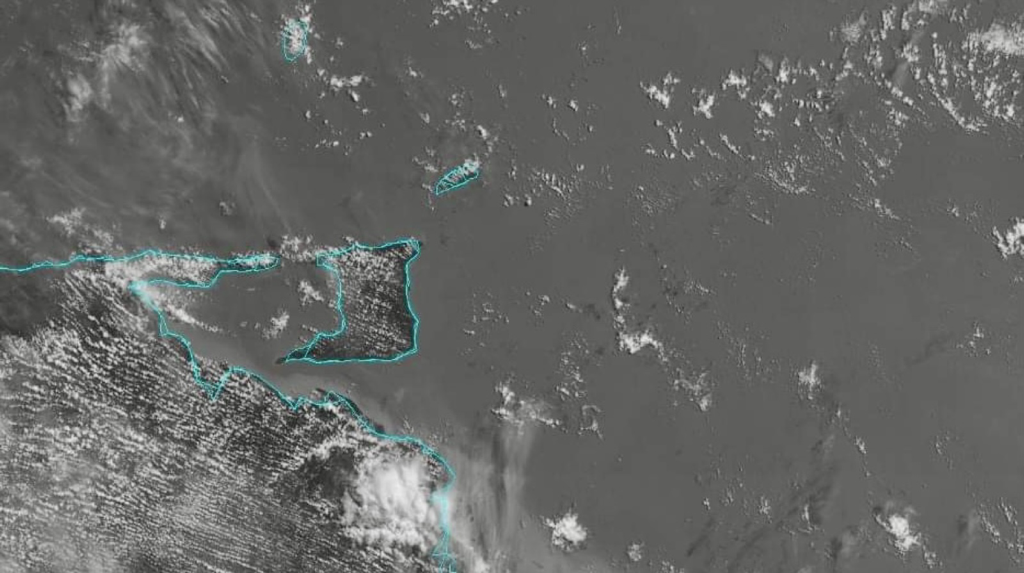 According to the Trinidad and Tobago Meteorological Service (TTMS), we can expect mostly fair but hazy and breezy conditions today (Wednesday 8th May, 2024), despite the low (20%) chance of a few brief isolated showers. Tonight will be fair but hazy and warm.
The Met Office notes that a significant concentration of Saharan dust is present in the atmosphere. Persons sensitive to these atmospheric conditions should take the necessary precautions. The forecast maximum temperature today will be 34°C at Piarco in Trinidad and 33°C at Crown Point in Tobago. Seas are slight to moderate with waves up to 1.5m in open waters and below 1m in sheltered areas. Please continue to pay attention to the latest forecasts, alerts, and information issued by the TTMS. 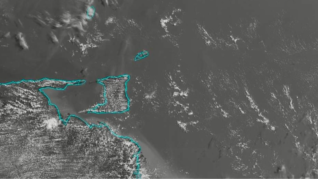 According to the Trinidad and Tobago Meteorological Service (TTMS), we can expect generally fair, hazy and breezy conditions today (Tuesday 7th May, 2024), despite the low (20%) chance of the isolated shower.
The Met Office notes that a significant concentration of Saharan dust is present in the atmosphere. Persons sensitive to these atmospheric conditions should take the necessary precautions. The forecast maximum temperature today will be 34°C at Piarco in Trinidad and 33°C at Crown Point in Tobago. Seas are slight to moderate with waves up to 1.5m in open waters and below 1m in sheltered areas. Please continue to pay attention to the latest forecasts, alerts, and information issued by the TTMS. 
According to the Trinidad and Tobago Meteorological Service (TTMS), an episode of high concentrations of Saharan dust in the atmosphere over Trinidad and Tobago began this past weekend, from Saturday (4th May, 2024). Concentration of the Saharan dust increased to moderate to mostly high at times, reducing visibility to four (4) to five (5) kilometers.
The Met Office notes that the present concentration is high. A short respite can be expected between Wednesday (8th May, 2024) to Thursday (9th May, 2024), when the dust is likely to be moderate to mild.
Subsequently, the Saharan dust concentration is expected to again rise to moderate to high from Friday (10th May, 2024), until at least early next week. Sensitive persons are advised to take the necessary precautions. Please continue to pay attention to the latest forecasts, alerts, and information issued by the TTMS. 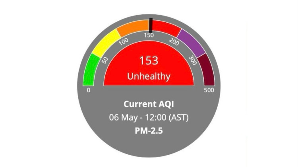
The Environmental Management Authority (EMA) is advising the public that the Air Quality Index (AQI) has registered UNHEALTHY in Port-of-Spain at 12:00 PM today (Monday 6th May, 2024), and SENSITIVE GROUPS at the Monitoring Stations of the EMA in Arima, Toco, Point Lisas, Mayaro and San Fernando.
The Trinidad and Tobago Meteorological Service (TTMS) said earlier today that a significant concentration of Saharan dust is present in the atmosphere. Persons who are sensitive to these changes in air quality are advised to take the necessary precautions.
The Air Quality Monitoring Network
The EMA, through the National Ambient Air Quality Monitoring Network has been obtaining accurate, real-time assessment of ambient air quality at strategic points nationally. The Air Quality Index (AQI) is a number used by Government agencies to communicate to the public how polluted the air currently is, or how polluted it is forecast to become. As the AQI rises, an increasingly large percentage of the population is likely to experience severe adverse health effects. There are currently six (6) Ambient Air Quality Monitoring stations in Trinidad and Tobago. Five (5) are located in Trinidad (Mayaro, Arima, Port-of-Spain, Point Lisas and San Fernando) and the sixth station is located at Signal Hill, Tobago. Members of the public are advised to visit the EMA's website and social media pages for daily updates on air quality in Trinidad and Tobago. Real time updates on air quality can also be accessed via this link: https://ei.weblakes.com/RTTPublic/DshBrdAQI. Please be guided accordingly.  According to the Trinidad and Tobago Meteorological Service (TTMS), we can expect generally dull, hazy and breezy conditions today (Monday 6th May, 2024), despite a low (20%) chance of a few isolated showers. Tonight will be fair but hazy.
The Met Office notes that a significant concentration of Saharan dust is present in the atmosphere. Persons who are sensitive to these changes in air quality are advised to take the necessary precautions. The forecast maximum temperature today will be 34°C at Piarco in Trinidad and 33°C at Crown Point in Tobago. Seas are moderate with waves up to 1.5m in open waters and below 1m in sheltered areas. Please continue to pay attention to the latest forecasts, alerts, and information issued by the TTMS.  According to the Trinidad and Tobago Meteorological Service (TTMS), the South-most end of a passing frontal system to the North-Northeast of the Lesser Antilles, continue to create low-level convergence and shear-lines across the Northern Leeward Islands. Throughout this outlook period (Saturday 4th to Wednesday 8th May, 2024), partly cloudy to cloudy conditions will interrupt some sunny periods, producing light to moderate showers over varying areas. The probability for the development of a heavy shower or thunderstorm increases towards the more Northerly islands.
The Southern Leeward and the Windward Islands are expected to be mostly fair, but with some low-level convergence, and patches of moisture advection interacting with the local topographies, there is likely to be a few brief showers in some areas with a 20% to 30% chance for a heavy shower to develop, mainly during the afternoon and near hilly areas. Analysis and models are showing an increase in equatorial moisture from the Southeast, passing across Trinidad and Tobago from Saturday (4th May, 2024) to Monday (6th May, 2024). Tomorrow (Saturday 4th May, 2024), a weak perturbation, together with low-level convergence, is likely to cause some fair conditions to be interrupted by partly cloudy periods with a light or moderate shower in a few areas. There is a 40% chance for a heavy shower mainly over Southeast Trinidad and hilly areas, and a 10% chance for a thunderstorm favouring Southwest Trinidad. On Sunday (5th May, 2024), a shift in the wind direction, backing from Southeast to East and East-Northeast, is expected to keep some of the equatorial moisture to the South of Trinidad, but low-level convergence, moisture advection, and some heating, is likely to produce partly cloudy periods in some areas with a few light or moderate showers and a 20% to 30% chance for a heavy shower. There is a 10% to 20% chance for thunderstorm activity over South and Southwestern offshore areas of Trinidad. Although the surface wind is expected to continue from the East-Northeast and East on Monday (6th May, 2024), a steady mid-level wind flow from the Southeast is likely to produce a resurgence of the equatorial moisture over Trinidad and Tobago during the morning. There is a 40% chance for a few heavy showers over Southern, Southwestern and Eastern offshore areas of Trinidad and on land over the Southwestern peninsular, with a 10% chance for a thunderstorm to develop. During the late morning to afternoon, there is the chance for a few light or moderate showers in some areas to interrupt fair conditions. A 20% to 30% chance exists for the development of a heavy shower over Western Trinidad or hilly areas. Tuesday (7th May, 2024) is expected to be mainly fair and sunny with brief showers in a few areas. Wednesday (8th May, 2024) would be generally fair, with some partly cloudy periods producing a few brief, light or moderate showers. In the event of a heavy shower or thunderstorm, winds can become gusty and street or flash flooding is likely in the vicinity. The Met Office notes that there is mild Saharan dust in the atmosphere at present. From tomorrow (Saturday 4th May, 2024), Saharan dust concentration in the atmosphere is expected to begin to increase to moderate concentrations, and eventually becoming high concentrations by Monday (6th May, 2024), for the remainder of this outlook period. In the event of any bush or brush fires, landfill or forest fires, together with the Saharan dust, a further reduction in air quality is to be expected. Sensitive persons are advised to take the necessary precautions. Please continue to pay attention to the latest forecasts, alerts, and information issued by the TTMS.  According to the Trinidad and Tobago Meteorological Service (TTMS), we can expect mostly fair conditions today (Friday 3rd May, 2024), interrupted at times by some light to moderate showers near Southern and hilly areas. There is a medium (40% to 60%) chance that some of these showers could become heavy. Tonight will be initially fair but becoming partly cloudy as the night progresses, with some isolated showers.
The Met Office notes that we can expect gusty winds, street and/or flash flooding in the vicinity of heavy showers/thunderstorms. The forecast maximum temperature today will be 34°C at Piarco in Trinidad and 32°C at Crown Point in Tobago. Seas are moderate with waves up to 2m in open waters and up to 1.5m in sheltered areas. Please continue to pay attention to the latest forecasts, alerts, and information issued by the TTMS.  The Trinidad and Tobago Meteorological Service (TTMS) is advising citizens to stay prepared for the upcoming 2024 Atlantic Hurricane Season, which begins on 1st June, 2024 and runs until 30th November, 2024.
Below is the list of twenty-one (21) tropical cyclone names that will be used for the 2024 Atlantic Hurricane Season (in alphabetical order):
The Met Office notes that there are six (6) lists of names for tropical cyclones that develop in the Caribbean Sea, the Gulf of Mexico, and the North Atlantic. The six (6) lists are used in rotation and recycled every six (6) years, (i.e. the 2024 list will be used again in 2030). The list of names covers only twenty-one (21) letters of the alphabet as it is difficult to find six (6) suitable names (one for each of the 6 rotating lists), starting with Q, U, X, Y and Z. Since 1953, Atlantic tropical cyclones have been named from lists originated by the National Hurricane Center (NHC) in Miami, Florida. They are now maintained and updated by an international committee of the World Meteorological Organization (WMO). For more information on tropical cyclone naming, visit: https://wmo.int/content/tropical-cyclone-naming. Please be guided accordingly.  According to the Trinidad and Tobago Meteorological Service (TTMS), we can expect predominantly sunny and at times breezy conditions today (Thursday 2nd May, 2024), despite the odd brief shower. There is the low (30%) chance of a heavy shower during the afternoon, mainly over Trinidad. Tonight will be clear.
The forecast maximum temperature today will be 34°C at Piarco in Trinidad and 33°C at Crown Point in Tobago. Seas are moderate with waves 1.5m to 2m in open waters and below 1m in sheltered areas. Please continue to pay attention to the latest forecasts, alerts, and information issued by the TTMS. |
AboutYouthere1 is a website focused on providing useful information, breaking news, entertainment and online shopping in Trinidad and Tobago.
AlertsSupportYouTubeContactPrivacyCategories
All
Archives
May 2024
|
 RSS Feed
