
UPDATE: In celebration of MovieTowne’s 17th Anniversary, Rituals is offering 10% off purchases over $25 on National Movie Day - Monday 25th November 2019. Offer available at MovieTowne POS, Price Plaza, C3 and Gulf City Tobago.

It’s that time of year again - MovieTowne’s “National Movie Day” - where you can watch movies all day long for just $15 each. National Movie Day takes place on Monday 25th November 2019 from 8:30am to 11:30pm at all MovieTowne locations.
MovieTowne is also celebrating 17 years of operations in T&T this year, having opened their first location back in 2002. MovieTowne promises “entertainment, giveaways & more” for National Movie Day. See the full schedule of available movies below and let us know which movies you’re excited to see in the comments. 
0 Comments

A Thunderstorm developed between Penal and Siparia this afternoon (Thursday 14th November 2019), which produced a Funnel Cloud. This Funnel Cloud only lasted 5 minutes and was spotted from Penal Rock Road between 1:30pm to 1:35pm.
Watch the video below and let us know your thoughts in the comments.
Elsewhere in South Trinidad, heavy rainfall, lightning and gusty winds were reported in Princes Town and environs. Flooding also occurred along the Solomon Hochoy Highway, near the Gasparillo Overpass.


The Ministry of Education has announced that all Schools will be closed on the day of Local Government Elections, Monday 2nd December 2019, as a number of Schools will serve as Voting Centers. School Principals are advised that all Schools will resume on Tuesday 3rd November 2019 as usual.
See the official announcement below from the Chief Education Officer at the Ministry of Education. 
[Source: CNC3]

Taylor Swift dropped the Official Remix to her hit song “Lover” out of nowhere on Wednesday 13th November 2019 and fans are loving it. The Lyric Video has already surpassed 1 Million views in just 8 hours and is currently #4 Trending on YouTube.
Watch the “Lover Remix” Lyric Video below as well as the Official Video for “Lover.” 
The Water and Sewerage Authority is advising customers in parts of Central and South West Trinidad that they will be without a pipe-borne water supply until further notice. This is due to an unplanned shutdown of the Point Lisas Desalination Plant on Friday 8th November 2019 caused by a leak on the Fiberglass Clearwell System at the Plant.
The Desalination Company of Trinidad and Tobago (Desalcott), which owns and operates the Plant, is currently assessing the full extent of damages and will then estimate the timeframe until repairs are completed. In the meantime, WASA will attempt to mitigate the effects of a supply shortfall by implementing the following strategies:
Desalcott supplies 40 Million Gallons of water daily to WASA, which is then used to supply the Point Lisas Industrial Estate, as well as augment the supply to areas in Central and South Trinidad.
The following areas will be without a pipe-borne water supply until further notice:
Affected customers are advised to carefully manage their stored water supplies as well as reduce consumption and eliminate wastage via leaks.
WASA Customer Call Centre: 800-4420/26 (Toll Free). [Source] 
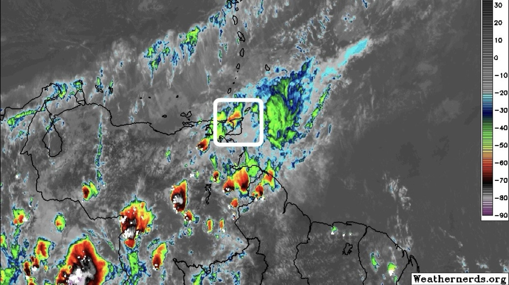
UPDATE (08/11/19 - 11:45am): As the ITCZ begins to affect T&T today, sustained winds of 41 Km/h have been recorded at Piarco as a line of heavy showers and gusty winds move across Trinidad. Heavier showers are favoring Central Trinidad at this time (via @TTWeatherCenter).

Tropical Wave 62 is forecast to move across the Lesser Antilles on Saturday 9th November 2019, with showers lingering into Sunday, bringing another round of showers and Thunderstorms to Trinidad and Tobago. This follows a rainy week which saw the passage of Tropical Waves 60 and 61, along with the Inter-Tropical Convergence Zone (ITCZ).
In addition to showers and Thunderstorms associated with Tropical Wave 62, no significant impacts are expected beyond isolated Street/Flash Flooding and gusty winds in heavier showers and Thunderstorms. This Wave is forecast to drag the ITCZ across the region yet again. See what the Met Office has to say about Tropical Wave 62 below and stay tuned for updates. There is a Tropical Wave to the east of T&T and the axis of this wave is expected to pass early on Saturday. This is expected to slightly increase the likelihood of showers and Thunderstorms tomorrow and Saturday. 
UPDATE: A Police Officer, Corporal Frank Issac, is confirmed to have died at the scene of the accident. He was driving his daughter to School in a silver SUV when a tire blew out, causing him to lose control and hit two (2) Red-Band Maxi Taxis. His daughter was rushed to Hospital. Issac was attached to the Guard and Emergency Branch in Aranguez.

A Red-Band Maxi Taxi and a silver vehicle collided head-on early this morning (Thursday 7th November 2019) on the Priority Bus Route near Olton Road in Arima. Initial reports indicate there is at least one fatality.
See some videos and photos from the accident scene below and stay tuned for updates as they become available.


UPDATE (05/11/19 - 3:15pm): The Met Office has adjusted its Adverse Weather Alert (Yellow Level) to now end at 4pm tomorrow, Wednesday 6th November 2019. Tropical Wave 61 is now West of the Islands, however with the presence of the ITCZ, showers and Thunderstorms remain in the forecast. There is a high possibility of Street/Flash Flooding and gusty winds in excess of 55 Km/hr in areas of heavy downpours.
UPDATE (05/11/19 - 1pm): According to the Met Office, so far today we've seen showers over a few areas and isolated Thunderstorms over parts of Northwest and Southwest Trinidad. Currently, the showers are remaining scattered, but a band is approaching from the East. This band is expected to bring showers, possible Thunderstorm activity and gusty winds.

Keep in mind that the rain events will be periodic, but can become intense at times, especially in terms of the winds.
Ahead of Tropical Wave 61, the Trinidad and Tobago Meteorological Service has issued an Adverse Weather Alert (Yellow Level) from 2pm on Tuesday 5th November to 7pm on Wednesday 6th November 2019.
Periods of showers and Thunderstorms, associated with the combination of a Tropical Wave and the Inter-Tropical Convergence Zone (ITCZ), are likely to affect various parts of Trinidad and Tobago. There is also the likelihood of winds gusting in excess of 55 Km/hr. Street/Flash Flooding or Landslips may occur in heavy downpours. This Alert covers the most likely time-frame for the most significant activity, but rainfall can still be expected outside of this period. See the Adverse Weather Alert from the Met Office below and stay tuned for updates. 

 UPDATE (04/11/19): As expected, the Met Office has issued an Adverse Weather Alert (Yellow Level) ahead of the passage of Tropical Wave 61. UPDATE (03/11/19): The Trinidad and Tobago Meteorological Service said today - “An Adverse Weather Alert is not in effect but stay tuned to our updates as we get closer.” They have also issued some key points to note for what we can expect:
 Pictured Above: Rough-looking, yellow/orange areas indicate the possible presence of Thunderstorm activity. The Inter-Tropical Convergence Zone (ITCZ) plus another two (2) Tropical Waves (60 and 61) are forecast to bring heavy rainfall to T&T, particularly on Tuesday 5th November and on Wednesday 6th November 2019 (expected to be the wettest day). Along with heavy rainfall, there will be an elevated threat of Flooding, Landslides and the possibility of gusty winds in excess of 65 Km/h. Moderate to rough seas are expected to continue throughout the week. The Met Office may issue an Adverse Weather Alert for Tuesday 5th November and Wednesday 6th November 2019 due to these expected conditions. There may also be a low chance of Riverine Flooding by the end of this week. According to the Met Office: Over the next few days, the passage of two Tropical Waves as well as an increase in low level winds can be expected.  Tropical Wave 60 will begin affecting T&T on Sunday 3rd November and into Monday 4th November 2019. The ITCZ then moves in on Tuesday and Tropical Wave 61 will follow later that day and into Wednesday. According to T&T Weather Center: Tuesday (5th Nov) - The ITCZ affects Trinidad and Tobago, with Tropical Wave 61 approaching, moving across the region by nightfall. Isolated showers are forecast to persist through the early morning into daybreak, becoming more scattered to widespread, and a few heavier showers and Thunderstorms developing by mid-morning. Scattered showers, rain, and Thunderstorms are forecast to persist throughout the day across both islands, with periods of mostly cloudy to overcast skies. Conditions are forecast to become temporarily settled by the evening, with a few lingering showers but activity is forecast to increase again after midnight. Increased wind speeds would result in higher gusts near Thunderstorms.  Stay tuned for updates throughout the week as we monitor these weather systems.

UPDATE 2: The death toll from this tragic accident has risen to two (2) as Private Kiel Quashie, a Soldier who was a passenger in the X-Trail, died at the Port-of-Spain General Hospital on Saturday evening (2nd November 2019).

UPDATE: A false report was made this morning on a local Radio Station stating that the Priority Bus Route (PBR) was open to the public. The Ministry of Works and Transport has since denied that report (see below).

Thousands of motorists were caught in gridlock traffic on their way into Port-of-Spain this morning, Friday 1st November 2019, following a major accident around 4:20am on the Beetham Highway. According to reports, a woman driving a Nissan X-Trail unsuccessful tried to overtake a Truck and instead crashed into it. The X-Trail was carrying at least one other passenger - a male. A total of five (5) persons were injured in the crash which caused traffic to be backed up as far as Grand Bazaar.
By the time emergency services arrived on the scene, several persons had already exited their vehicles while others had to be physically removed. Fire Officers took all injured persons to the Port-of-Spain General Hospital, where an unidentified woman was declared dead. It appears she was the driver of the X-Trail. The deceased woman’s father told CNC3 News that he spoke to his daughter around 2am and at the time, she was at a Halloween party and told him that she was having fun. The passenger in the Nissan X-Trail, identified only as ‘Quashie,’ sustained serious head injuries and is listed in critical condition. He was transferred to the Intensive Care Unit and his family is pleading for blood donations as he requires eight (8) Pints for emergency surgery. The other three (3) persons are also said to be warded in critical condition. See some photos from the accident scene below and stay tuned for updates. 

|
AboutYouthere1 is a website focused on providing useful information, breaking news, entertainment and online shopping in Trinidad and Tobago.
AlertsSupportYouTubeContactPrivacyCategories
All
Archives
March 2024
|
 RSS Feed
