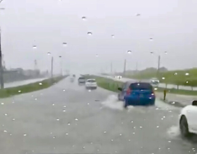
UPDATE (1:05pm): The Southbound lane of the Solomon Hochoy Highway is flooded near Freeport.
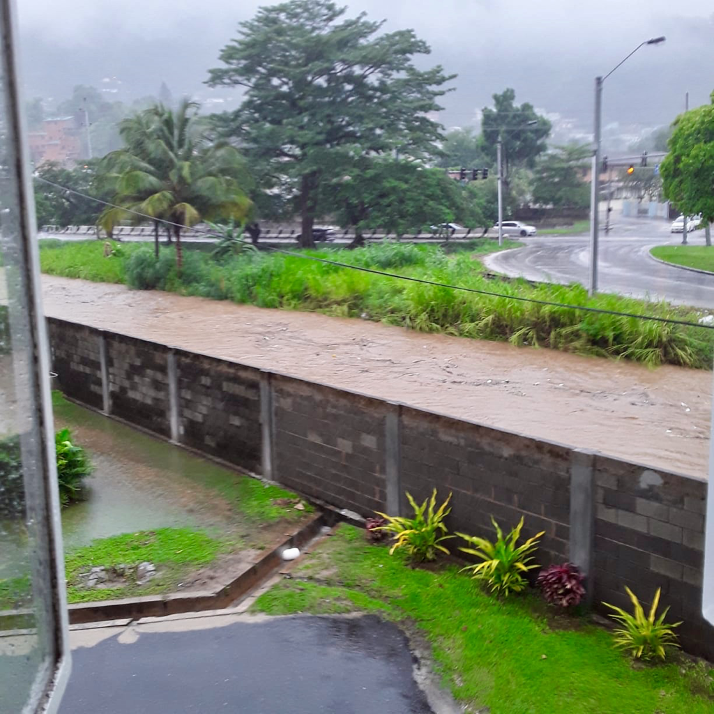
UPDATE (12:45pm): The Diego Martin River is currently at its threshold as heavy rains countinue.
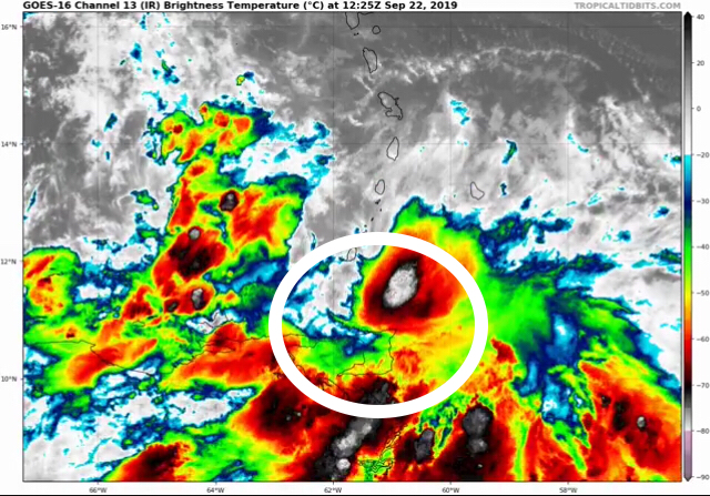
UPDATE (12:25pm): Flooding has begun on the Chagaunas Main Road as Tropical Storm Karen moves over the Island.
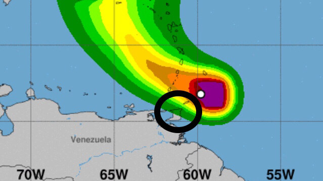
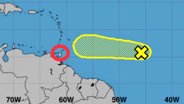
UPDATE (11am): The center of Tropical Storm Karen is currently located near Latitude 12.5 North and Longitude 61.7 West. Karen is moving toward the West-Northwest near 13 Mph (20 Km/h) and this general motion is expected to continue today. A turn toward the Northwest is forecast to occur on Monday, followed by a turn toward the North on Tuesday.
On the Forecast Track, the center of Karen will move away from the Windward Islands later today, and then across the Eastern Caribbean Sea tonight and Monday. On Tuesday, Karen is expected to approach Puerto Rico and the Virgin Islands. Maximum sustained winds are near 40 Mph (65 Km/h) with higher gusts. Little change in strength is forecast during the next 48 hours. 
UPDATE (10:15am): The Minister of National Security is assuring citizens that Tropical Storm Karen is being closely monitored. The Office of Disaster Preparedness and Management (ODPM) and the Met Office are co-ordinating with key Stakeholders such as the Protective Services and several Ministries.
UPDATE: The Met Office has also issued a Red Level Alert for this Tropical Storm.
Tropical Storm Warnings have been issued for Trinidad & Tobago, Grenada and its Dependencies as the approaching strong Tropical Wave was upgraded to Tropical Storm Karen at 5am on Sunday 22nd September 2019. A Tropical Storm Warning means that Tropical Storm conditions are expected somewhere within the warning area, in this case within the next 12 hours.
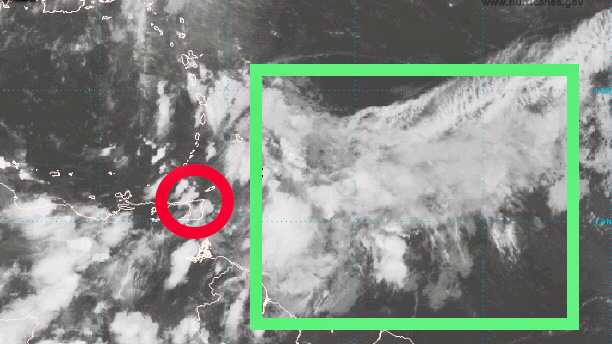
Tropical Storm Karen is expected to move across Trinidad & Tobago later this morning (Sunday 22nd September 2019) and emerge over the South-Eastern Caribbean Sea by Monday morning. As of 5am this morning, the center of Karen was located approximately 80 Km Northeast of Tobago.
Tropical Storm Warnings may be issued later today for other portions of the Windward Islands. A Tropical Storm Watch will likely be issued later today for Puerto Rico and the Virgin Islands. Elsewhere, interests in the Leeward Islands should monitor the progress of Karen.
See the Tropical Storm Advisory from the Met Office below and stay tuned for important weather updates. 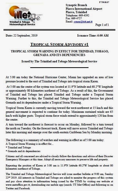


0 Comments
Breaking: Met Office Raises Adverse Weather Alert To Orange Level For ‘Intense Tropical Wave’21/9/2019 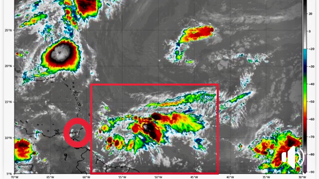
UPDATE (22/09/19 - 8am): T&T is now under a Tropical Storm Warning as the Tropical Wave was upgraded to Tropical Storm Karen. The Met Office has also issued a Red Level Alert for this Tropical Storm.
At approximately 1:30pm on Saturday 21st September 2019, the Trinidad and Tobago Meteorological Service elevated its previous Adverse Weather Alert from Yellow to Orange Level. This action was taken ahead of what it now describes as an ‘intense Tropical Wave,’ which is expected to impact T&T between 6am on Sunday 22nd September and 8pm on Monday 23rd September 2019.
According to the Met Office, analysis of the latest data has increased the certainty of impactful weather. On the Risk Matrix, a high certainty of severe impact warrants a change to Orange Level.
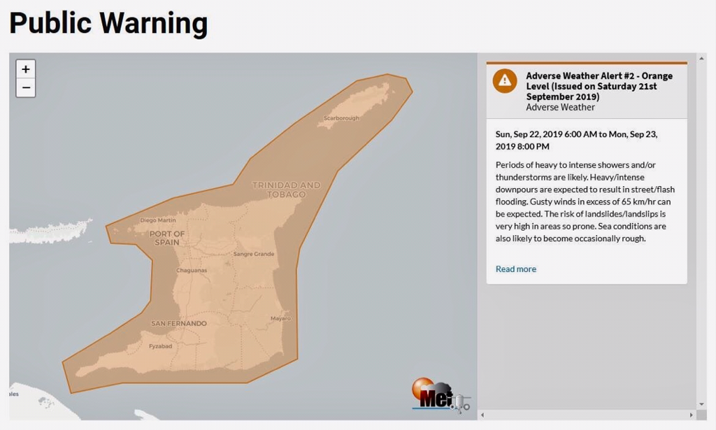
The approaching Tropical Wave is expected to move through the area between Sunday 22nd September and Monday 23rd September 2019. Periods of heavy to intense showers and/or Thunderstorms are likely. Heavy/intense downpours are expected to result in Street/Flash Flooding. Gusty winds in excess of 65 Km/hr can be expected. The risk of Landslides/Landslips is very high in areas so prone. Sea conditions are also likely to become occasionally rough. Keep in mind that the above time-frame is an estimate for the most intense activity and it does not mean that showers and Thunderstorms won't be present beforehand. See the elevated Adverse Weather Alert from the Met Office below and be sure to stay tuned for further updates. 

UPDATE (22/09/19 - 8am): T&T is now under a Tropical Storm Warning as the Tropical Wave was upgraded to Tropical Storm Karen. The Met Office has also issued a Red Level Alert for this Tropical Storm.
UPDATE (21/09/19): The Met Office has now raised its Adverse Weather Alert to Orange Level ahead of this intense Tropical Wave.
Ahead of a strong Tropical Wave, the Trinidad and Tobago Meteorological Service has issued an Adverse Weather Alert (Yellow Level) from 6am on Sunday 22nd September to 8pm on Monday 23rd September 2019.
The Alert Level has been raised to yellow, as the approaching Tropical Wave is likely to affect T&T between Sunday 22nd September and Monday 23rd September 2019. There is medium (40-60%) chance of heavy to intense showers and/or Thunderstorms developing from Sunday morning. Significant rainfall will continue into Monday. Heavy/intense downpours will lead to Street/Flash Flooding. Gusty winds in excess of 65 Km/hr can be expected. The risk of Landslides/Landslips is very high in areas so prone.
See the Adverse Weather Alert from the Met Office below and stay tuned for updates as the weekend progresses. 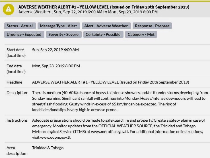

Almost four decades after he drew first blood, Sylvester Stallone is back as one of the greatest action heroes of all time, John Rambo. Now, Rambo must confront his past and unearth his ruthless combat skills to exact revenge in a final mission. A deadly journey of vengeance, Rambo: Last Blood marks the last chapter of the legendary series and hits Theaters on 20th September 2019.
Watch the Official Trailer for Rambo: Last Blood below and let us know your thoughts in the comments. 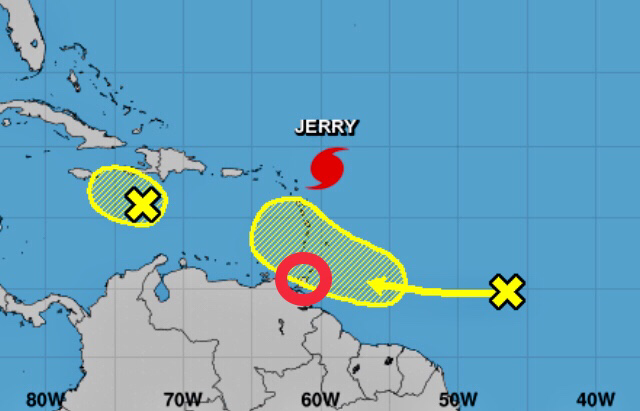
UPDATE (24/09/19 - 6pm): The Adverse Weather Alert was discontinued before 4pm on Monday 23rd September 2019 and the Riverine Flood Warning was discontinued around 1:30pm on Tuesday 24th September 2019. Thank you for following and sharing our weather updates over these past few days!
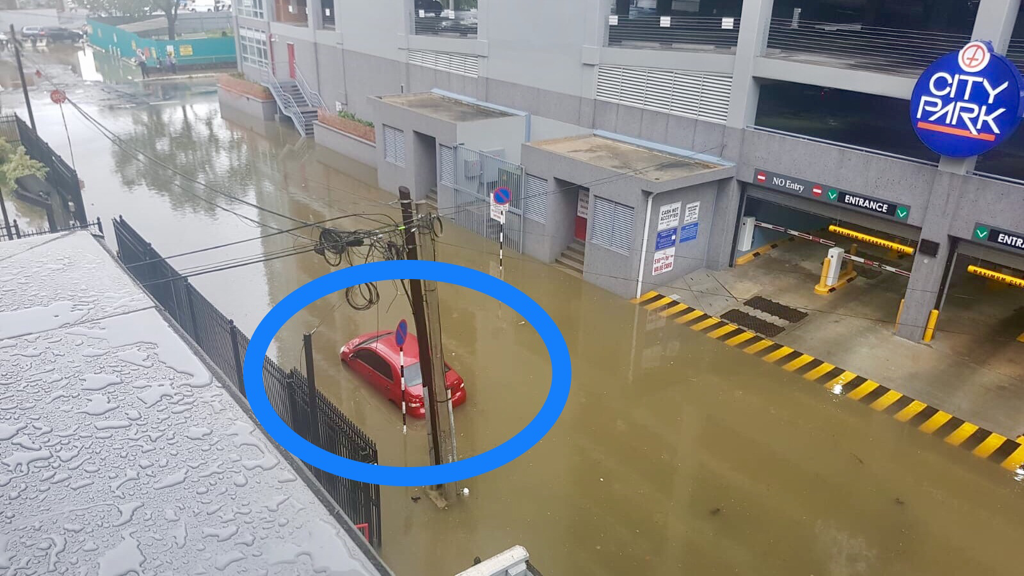
UPDATE (22/09/19 - 6:30pm): The Trinidad and Tobago Police Service (TTPS) has blocked motorists from attempting to drive through flood waters on the Highways by Grand Bazaar.
UPDATE (22/09/19 - 4:30pm): Minister of National Security, Stuart Young, has announced that all Schools across Trinidad & Tobago will be closed on Monday 23rd September 2019.
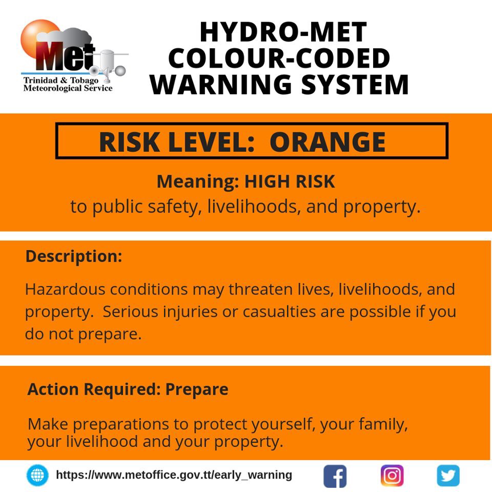
UPDATE (22/09/19 - 3pm): The Met Office has discontinued the Tropical Storm Warning as Karen is moving away, but T&T is now under an Adverse Weather Alert (Orange Level) as well as a Riverine Flood Warning (Red Level).
UPDATE (22/09/19 - 8am): T&T is now under a Tropical Storm Warning as the Tropical Wave was upgraded to Tropical Storm Karen. The Met Office has also issued a Red Level Alert for this Tropical Storm.
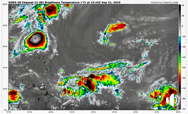
UPDATE (21/09/19 - 8pm): While this strong Tropical Wave does not yet have a well-defined circulation, a NOAA Hurricane Hunter mission earlier this afternoon indicated that the Wave is producing winds of 35 Mph (56 Km/h). At least gradual development of this system is expected, and a Tropical Depression or Tropical Storm could form during the next couple of days. Regardless of development, heavy rainfall is still forecast across T&T.
UPDATE (21/09/19 - 2pm): The Met Office has now raised its Adverse Weather Alert to Orange Level ahead of this intense Tropical Wave.
UPDATE: Due to the intensity of this approaching Tropical Wave, the Met Office has issued an Adverse Weather Alert for 38 hours. Be prepared and stay tuned for further updates.
The Trinidad and Tobago Meteorological Service as well as the National Hurricane Center (NHC) are both monitoring a Tropical Wave that is expected to bring significant rainfall to T&T between Sunday 22nd September and Monday 23rd September 2019.
According to the Met Office, the chance of Tropical Cyclone development remains low, however, persons should be prepared in the event that changes occur. Regardless of development, heavy rainfall is forecast across T&T and the Southern Windward Islands on Sunday and into Monday. Seas are forecast to become moderate to rough from late Saturday through Monday. There will also be an elevated threat of Street/Flash/Riverine Flooding on Monday, as well as Landslides and gusty winds. If you live in flood-prone areas or areas susceptible to Landslides, make sure you have an emergency plan in place and supplies available in case of an emergency. 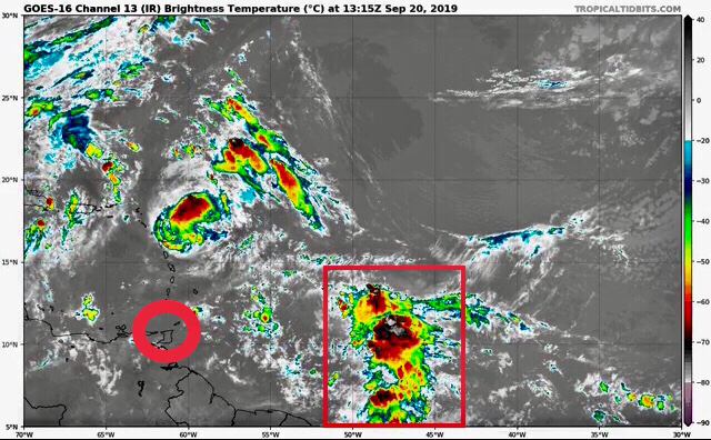
T&T is not currently under an Alert or Tropical Storm Watch/Warning at this time, but there is a possibility that this may change soon.
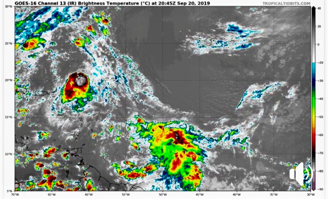
As of 8am this morning (Friday 20th September 2019), the Tropical Wave was located about 700 Miles (1,127 Kilometers) East of the Windward Islands and continues to produce disorganized showers and Thunderstorms. The Wave is expected to move quickly Westward at about 20 Mph (32 Km/h) during the next few days, and some development is possible while it approaches and moves across the Windward Islands this weekend. 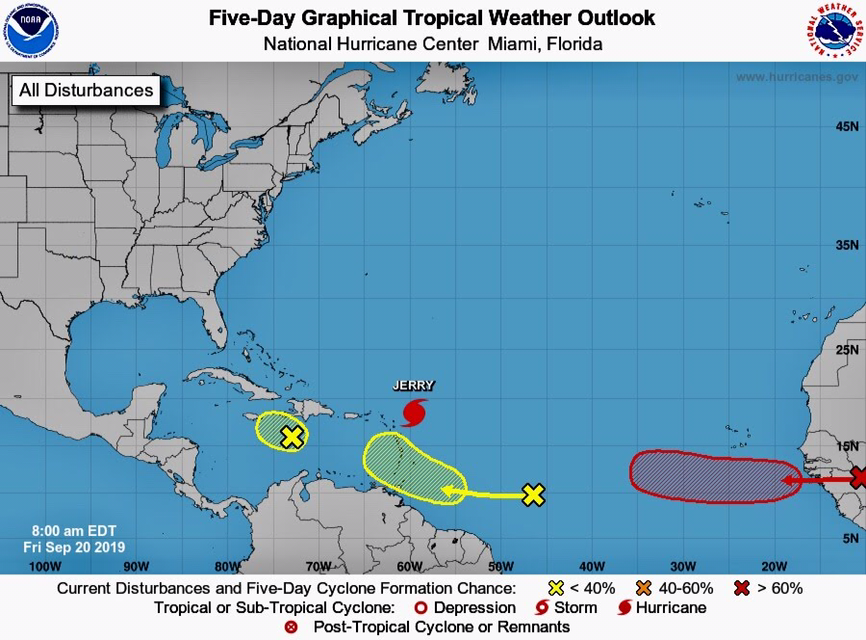
This is a developing story - stay tuned for updates.

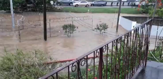
The Diego Martin River and Maraval River have burst its banks shortly after 1pm on Wednesday 18th September 2019 due to heavy rainfall. Travel is not advised along both the Diego Martin Highway and Diego Martin Main Road as Flash Flooding is occurring there as well as in surrounding areas. Reports indicate persons working at the Maraval WASA Station are marooned.
An Adverse Weather Alert was issued by the Met Office and remains in effect until 6pm on Wednesday 18th September 2019. See some photos from the Diego Martin area below and stay tuned for updates. 

UPDATE 3: According to the Met Office, periods of light to moderate showers and/or rain will continue today (Tuesday 17th September 2019). There is a low to medium chance (25-45%) of intense showers and/or Thunderstorms for the remainder of the day and a high chance (80%) towards Midnight into tomorrow morning.
This rainfall activity will be intermittent with some settled intervals but in the event of heavy or intense downpours, Street/Flash Flooding and gusty winds can be expected. The possibility of Landslides/Landslips is also heightened during the period. Water levels in the main river courses remain contained at this time.
UPDATE 2: As we experience adverse weather conditions across T&T, the Office of Disaster Preparedness and Management (ODPM) is reminding persons to be extra vigilant and to proceed with caution in flood-prone and landslip-prone areas.
UPDATE: As expected, a multi-day heavy rainfall event has started due to the lingering presence of the ITCZ across the region throughout the week.
The Trinidad and Tobago Meteorological Service has issued an Adverse Weather Alert (Yellow Level) from 11am on Tuesday 17th September to 8pm on Wednesday 18th September 2019.
According to the Met Office, there is a medium chance (65%) of intense showers and/or Thunderstorms developing by late morning on Tuesday and a high chance (80%) during pre-dawn hours on Wednesday. Street/Flash Flooding and gusty winds are also expected. 
The Inter-Tropical Convergence Zone (ITCZ) is forecast to bring periods of showers and Thunderstorms to T&T over the next several days with an elevated risk of Street, Flash and Riverine Flooding as the week progresses.
See the Adverse Weather Alert from the Met Office below and stay tuned for updates. 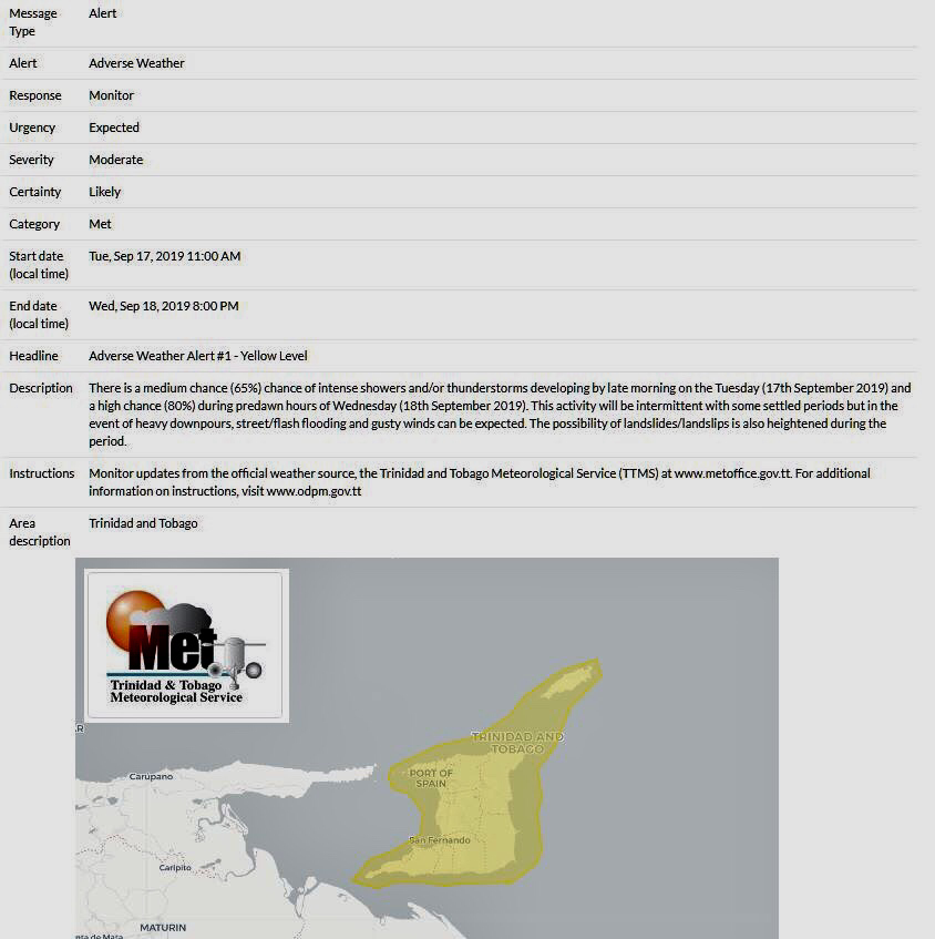
Apple wrapped up a very busy iPhone Event on Tuesday 10th September 2019, revealing several new iPhones, a new Apple Watch Series 5 as well as new services (Apple Arcade, Apple TV+).
If you missed the iPhone Event, you can watch it here in its entirety. The iPhone 11 models consist of the iPhone 11 (successor to iPhone XR), iPhone 11 Pro and iPhone 11 Pro Max. This is the first time Apple is using the “Pro” name on an iPhone. Last year’s iPhone XR turned out to be the best-selling iPhone model, which had a starting price of US $749. This year, the XR’s successor - the iPhone 11 - starts at an even lower price point of US $699 and comes packed with much more features than the XR. 
While the iPhone 11 maxes out at 256GB of storage (US $849), you can get as much as 512GB on the iPhone 11 Pro Max (US $1,449). All iPhone 11 models have ditched the pressure-sensitive (3D Touch) screens of previous models and instead now uses Haptic Touch, which gives you a similar feeling (and features) to that of 3D Touch.

iPhone 11 - Tech Specs:
TrueDepth (Front) Camera:
iPhone 11 - Prices:
The iPhone 11 Pro models are available in two (2) sizes: 5.8” and 6.5” for the iPhone 11 Pro Max. Both feature a triple lens camera setup at the back for shooting very high-quality photos and videos. iOS 13 will also allow for powerful editing of both photos and videos on the go.
In addition to the technical specs for the iPhone 11 listed above, there are several differences for the iPhone 11 Pro. 
iPhone 11 Pro - Additional Tech Specs:
iPhone 11 Pro - Prices:
In addition to the technical specs for the iPhone 11 Pro listed above, there are several differences for the iPhone 11 Pro Max.

iPhone 11 Pro Max - Additional Tech Specs:
iPhone 11 Pro Max - Prices:
Pre-orders for all three (3) iPhone models begin early on Friday 13th September 2019 and will arrive a week later on Friday 20th September 2019.

Excitement is building even more as we get closer to the start of Apple’s 2019 Event at 1pm EST/10am PDT on Tuesday 10th September. Be sure to catch up on all the last minute predictions before the Event begins!
The latest rumors suggest the three (3) new iPhones will be called: iPhone 11, iPhone Pro and iPhone Pro Max. Reverse Wireless Charging on this year’s iPhones is rumored to have been scrapped due to technical issues and there will apparently be no Apple Pencil support this year. These are all last minute rumors of course, so they can all be inaccurate. We’ll find out all the details very shortly! Tune into Apple’s Live Stream below from 1pm EST/10am PDT. 

Apple’s iPhone Event kicks off at 1pm EST/10am PST on Tuesday 10th September 2019 at the Steve Jobs Theater in Cupertino, California. After at least a year of rumors and leaks, what can we really expect to see at this year’s highly-anticipated iPhone Event?
Some of the new devices we expect include:
Of course there will also be new details on iOS 13, iPadOS 13, macOS Catalina, tvOS 13 and watchOS 6. Watch a pair of videos below from Tailosive Tech and ZONEofTECH for a complete look at everything we can expect to see at Apple’s upcoming iPhone Event. |
AboutYouthere1 is a website focused on providing useful information, breaking news, entertainment and online shopping in Trinidad and Tobago.
AlertsSupportYouTubeContactPrivacyCategories
All
Archives
March 2024
|
 RSS Feed
